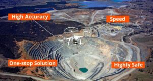
The mining industry is undergoing a significant transformation with the advent of modern technology. Among these advancements, aerial surveys have emerged as a groundbreaking tool, offering a new perspective on how mining operations are conducted. Utilizing drones and other aerial technologies, aerial surveys provide accurate, efficient, and comprehensive data that is essential for effective mining operations. This article delves into the benefits, applications, and future prospects of aerial surveys in the mining industry, showcasing why they are becoming indispensable.
Understanding Aerial Surveys in Mining
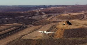
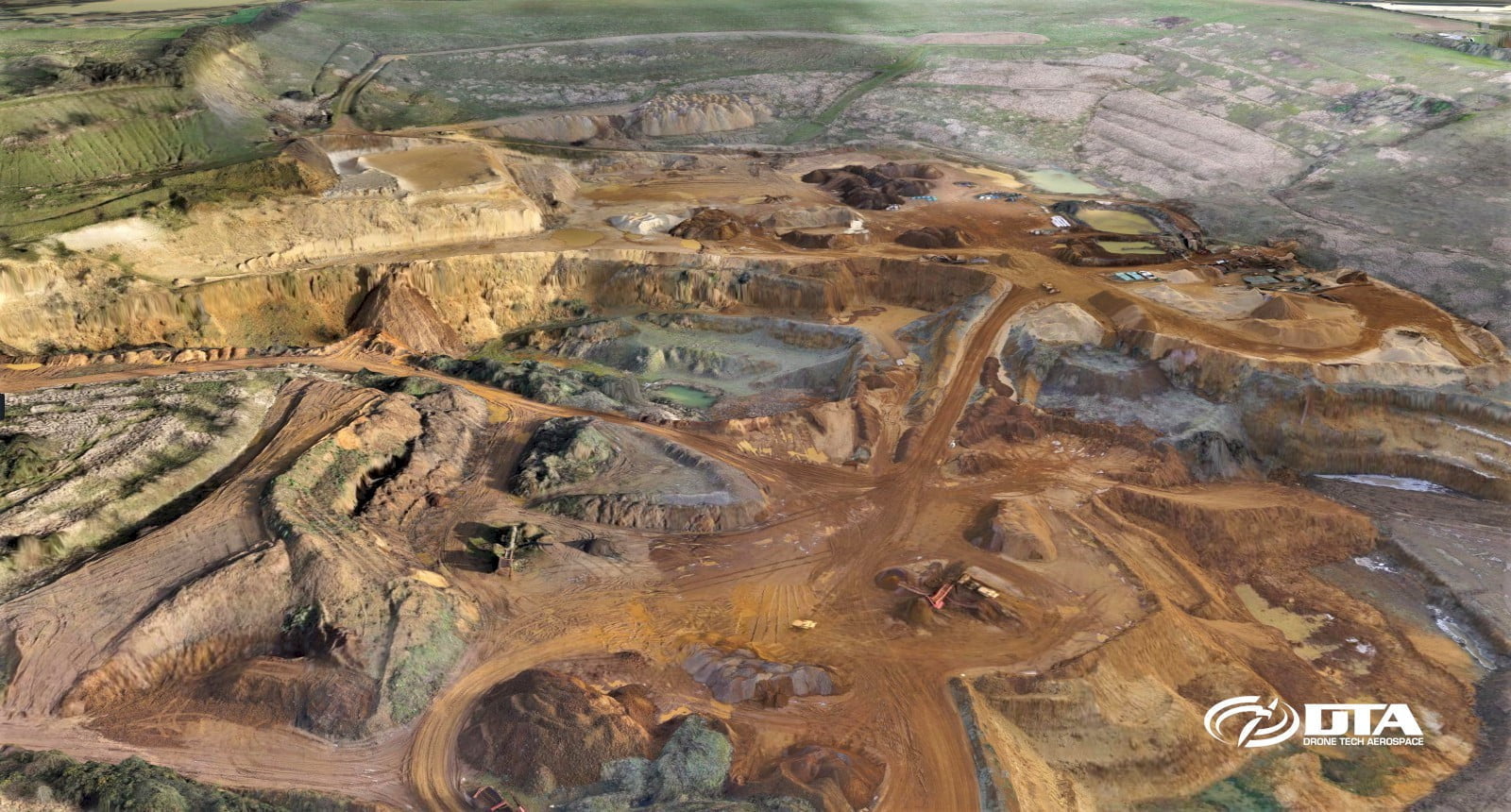
Aerial surveys involve using drones, also known as unmanned aerial vehicles (UAVs), or other aerial platforms equipped with high-resolution cameras, lidar, and other sensors to capture detailed images and data from the air. This technology allows for the creation of precise maps, 3D models, and other geospatial data crucial for various mining activities, from exploration to reclamation.
Benefits of Aerial Surveys in Mining
1. Increased Efficiency and Speed
Traditional ground-based surveying methods can be time-consuming and labor-intensive, especially in large or difficult-to-access mining sites. Aerial surveys can cover vast areas quickly, capturing high-resolution data in a fraction of the time required by conventional methods. This increased efficiency translates into faster project completion and reduced operational costs.
2. High Accuracy and Precision
Modern aerial survey technologies provide high accuracy and precision, thanks to advanced sensors and GPS technology. Drones equipped with lidar and photogrammetry capabilities can produce detailed topographic maps and 3D models with centimeter-level accuracy. This level of precision is essential for planning, resource estimation, and ensuring compliance with regulatory standards.
3. Enhanced Safety
Mining operations often involve hazardous and challenging environments. Aerial surveys eliminate the need for surveyors to physically access dangerous areas, significantly reducing the risk of accidents and injuries. By using drones to conduct surveys, mining companies can enhance safety for their personnel while still obtaining the necessary data.
4. Cost-Effectiveness
While the initial investment in aerial survey technology may be significant, the long-term cost savings are substantial. Aerial surveys reduce the need for extensive ground-based labor and equipment, and their efficiency means projects can be completed more quickly. Additionally, the high accuracy of aerial survey data minimizes the risk of costly errors and rework.
5. Comprehensive Data Collection
Aerial surveys provide comprehensive data collection, capturing high-resolution images, topographic data, and other geospatial information. This detailed data allows for thorough analysis and reporting, enabling better decision-making and project planning. The ability to create 3D models and digital elevation models (DEMs) further enhances the utility of aerial surveys.
Applications of Aerial Surveys in Mining
Aerial surveys have a wide range of applications in the mining industry, from exploration to post-mining activities. Here are some of the most common uses:
1. Exploration and Resource Estimation
During the exploration phase, aerial surveys are used to map and analyze potential mining sites. High-resolution images and lidar data provide detailed information about the terrain, geological features, and mineral deposits. This data is crucial for identifying viable mining locations and estimating the quantity and quality of resources.
2. Mine Planning and Design
Aerial surveys play a critical role in mine planning and design. Detailed topographic maps and 3D models help engineers design efficient and safe mine layouts. Accurate data on the terrain and geological conditions enable better planning of access roads, waste disposal sites, and other infrastructure.
3. Monitoring and Inspection
Regular monitoring and inspection are essential for ensuring the safety and efficiency of mining operations. Aerial surveys provide real-time data on the condition of the mine, including pit walls, tailings dams, and other critical structures. This data helps identify potential hazards and allows for timely interventions to prevent accidents and operational disruptions.
4. Environmental Impact Assessment
Mining operations can have significant environmental impacts, and aerial surveys are instrumental in assessing and mitigating these effects. High-resolution images and multispectral data can monitor vegetation, water bodies, and other environmental features. This information helps mining companies comply with environmental regulations and implement sustainable practices.
5. Reclamation and Closure
After mining operations have ceased, aerial surveys are used to plan and monitor reclamation efforts. Detailed data on the post-mining landscape helps design effective reclamation strategies, such as regrading, replanting, and erosion control. Aerial surveys also provide documentation of the reclamation process, ensuring compliance with regulatory requirements.
The Future of Aerial Surveys in Mining
The future of aerial surveys in mining is promising, with continuous advancements in technology and increasing adoption across the industry. Here are some trends to watch for in the coming years:
1. Integration with Artificial Intelligence
The integration of artificial intelligence (AI) with aerial survey technology will enhance data analysis and decision-making. AI algorithms can process the vast amounts of data collected by drones, identifying patterns and trends that may not be immediately apparent. Machine learning can also improve the accuracy of resource estimation and predictive analytics, helping mining companies make proactive decisions.
2. Autonomous Drones
Autonomous drones capable of performing surveys without human intervention are on the horizon. These drones can be programmed to conduct regular surveys, upload data to the cloud, and even charge themselves between flights. Automation will further increase efficiency and reduce labor costs, allowing mining companies to focus on other critical aspects of operations.
3. Advanced Sensors and Cameras
Advancements in sensor and camera technology will improve the capabilities of aerial surveys. Higher-resolution cameras, multispectral and hyperspectral sensors, and advanced lidar technology will provide more detailed and accurate data. These improvements will expand the applications of aerial surveys and provide even greater value to mining companies.
4. Real-Time Data Processing
Cloud-based platforms and real-time data processing will enable mining companies to access and analyze aerial survey data more quickly. This real-time data can be used to make immediate decisions about mine planning, safety, and environmental management. Improved data processing capabilities will also enhance collaboration between mining companies, regulators, and other stakeholders.
5. Increased Accessibility
As aerial survey technology becomes more affordable and user-friendly, it will become accessible to a broader range of mining companies, including small and medium-sized enterprises. This democratization of technology will help bridge the gap between large and small mining operations, promoting efficient and sustainable mining practices worldwide.
Choosing an Aerial Survey Service Provider
With the growing demand for aerial survey services in mining, selecting the right service provider is crucial for achieving the best results. Here are some factors to consider when choosing an aerial survey service provider:
1. Experience and Expertise
Look for a provider with extensive experience in aerial surveys and a proven track record of successful projects in the mining industry. Expertise in your specific type of mining operation (e.g., open-pit, underground) is also important, as different mining activities have unique requirements and challenges.
2. Technology and Equipment
Ensure that the provider uses advanced drones and sensors capable of capturing the high-quality data you need. The provider should also have access to specialized software for data processing and analysis.
3. Regulatory Compliance
Drone operations are subject to various regulations and restrictions, depending on the location and type of work being performed. Choose a provider that is knowledgeable about the relevant regulations and has the necessary licenses and certifications to operate drones legally and safely.
4. Customer Support
Good customer support is essential for a successful partnership. Choose a provider that offers responsive and reliable support, from the initial consultation to the delivery of the final results. This ensures that any issues or concerns can be addressed promptly and effectively.
Conclusion
Aerial surveys are revolutionizing the mining industry by providing accurate, efficient, and comprehensive data that is essential for various mining activities. The benefits of using aerial surveys in mining are numerous, including increased efficiency, high accuracy, enhanced safety, cost-effectiveness, and comprehensive data collection. With a wide range of applications, from exploration to reclamation, aerial surveys are becoming an indispensable tool for modern mining operations.
The future of aerial surveys in mining is bright, with advancements in AI, automation, sensors, and real-time data processing set to further enhance their capabilities. As aerial survey technology becomes more accessible, it will continue to transform traditional mining practices, promoting efficient and sustainable mining operations worldwide.
For mining companies looking to stay ahead in the competitive landscape, adopting aerial survey technology is a smart move. By leveraging the power of aerial surveys, mining companies can optimize their operations, reduce environmental impact, and ensure a sustainable and profitable future for the industry. The sky is no longer the limit—it’s the beginning of a new era in mining.