Rajasthan, the largest state in India by area, is known for its rich cultural heritage, diverse landscapes, and robust industrial activities. In recent years, the integration of drone technology has begun to revolutionize various sectors in Rajasthan, including agriculture, mining, urban planning, and infrastructure development. Drone surveys have emerged as a powerful tool, offering precise, efficient, and cost-effective solutions for data collection and analysis. This article explores the benefits, applications, and prospects of drone surveys in Rajasthan, showcasing how this technology is transforming the region.
Understanding Drone Surveys
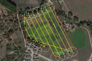
A drone survey involves using unmanned aerial vehicles (UAVs) equipped with high-resolution cameras, lidar, and other sensors to capture detailed images and data from the air. This technology allows for the creation of accurate maps, 3D models, and other geospatial data essential for various applications. The use of drones significantly enhances the efficiency and accuracy of data collection, making them invaluable for numerous industries.
Benefits of Drone Surveys in Rajasthan
1. High Accuracy and Precision
Drone surveys provide high levels of accuracy and precision, thanks to advanced sensors and GPS technology. This accuracy is crucial for applications such as land surveying, construction planning, and agricultural monitoring. Drones can capture high-resolution images and generate detailed maps and 3D models with centimeter-level precision.
2. Increased Efficiency and Speed
Traditional ground-based surveying methods can be time-consuming and labor-intensive, particularly in vast or difficult-to-access areas. Drones can cover large areas quickly and efficiently, capturing detailed data in a fraction of the time required by conventional methods. This increased efficiency translates into faster project completion and reduced operational costs.
3. Enhanced Safety
Surveying and data collection often involve working in hazardous or challenging environments. Drones eliminate the need for surveyors to physically access dangerous areas, significantly reducing the risk of accidents and injuries. Whether it’s a steep hillside, a dense forest, or a busy construction site, drones can safely and efficiently capture the necessary data.
4. Cost-Effectiveness
While the initial investment in drone technology may be substantial, the long-term cost savings are significant. Drones reduce the need for extensive ground-based labor and equipment, and their efficiency means projects can be completed more quickly. Additionally, the high accuracy of drone data minimizes the risk of costly errors and rework.
5. Comprehensive Data Collection
Drones can capture a wide range of data, including high-resolution images, thermal data, and multispectral imagery. This comprehensive data collection allows for detailed analysis and reporting, enabling better decision-making and project planning. The ability to create 3D models and topographic maps further enhances the utility of drone surveys.
Applications of Drone Surveys in Rajasthan
Drone surveys have a wide range of applications across various industries in Rajasthan. Here are some of the most common uses:
1. Agriculture
Agriculture is a vital sector in Rajasthan, and drone surveys are playing a significant role in modernizing farming practices. Drones equipped with multispectral sensors can monitor crop health, assess soil conditions, and plan irrigation systems. This precision agriculture approach helps increase yields, reduce resource use, and improve overall farm management.
2. Mining
Rajasthan is rich in mineral resources, and the mining industry is a significant contributor to the state’s economy. Drone surveys are used for site exploration, resource estimation, and operational monitoring. Drones can quickly survey mining sites, providing accurate topographic maps and 3D models that are crucial for planning and resource management. Regular drone flights can also monitor mining operations, ensuring compliance with safety and environmental regulations.
3. Urban Planning and Development
Urban planners in Rajasthan use drone surveys to create detailed maps and models of urban areas, helping in the planning and development of infrastructure projects. Drones can capture high-resolution images of buildings, roads, and other infrastructure, providing valuable data for planning and decision-making. This technology also supports smart city initiatives by providing real-time data on urban environments.
4. Infrastructure Development
The construction industry in Rajasthan is benefiting significantly from drone surveys. Drones are used for site surveys, progress monitoring, and inspections. They can quickly survey large construction sites, providing accurate topographic maps and 3D models essential for planning and design. Regular drone flights can also monitor construction progress, ensuring that projects stay on schedule and within budget.
5. Environmental Monitoring
Rajasthan’s diverse landscapes, including deserts, forests, and wetlands, require careful monitoring and management. Drones are valuable tools for environmental monitoring and conservation efforts. They can survey large and remote areas to assess changes in vegetation, monitor wildlife, and detect environmental hazards. Drone surveys are also used in disaster response, providing real-time data on areas affected by natural disasters such as floods and droughts.
The Future of Drone Surveys in Rajasthan
The future of drone survey in Rajasthan is promising, with continuous advancements in technology and increasing adoption across various industries. Here are some trends to watch for in the coming years:
1. Integration with Artificial Intelligence
The integration of artificial intelligence (AI) with drone technology will enhance data analysis and decision-making. AI algorithms can process the vast amounts of data collected by drones, identifying patterns and trends that may not be immediately apparent. Machine learning can also improve the accuracy and reliability of drone surveys by learning from past data and identifying patterns.
2. Improved Sensors and Cameras
Advancements in sensor and camera technology will enhance the capabilities of drone surveys. Higher-resolution cameras, multispectral and hyperspectral sensors, and lidar technology will provide more detailed and accurate data. These improvements will expand the applications of drone surveys and provide even greater value to users.
3. Increased Automation
The development of fully automated drones that can perform surveys without human intervention is on the horizon. These drones can be programmed to conduct regular surveys, upload data to the cloud, and even charge themselves between flights. Automation will further increase the efficiency and cost-effectiveness of drone surveys.
4. Enhanced Data Processing and Visualization
Advancements in data processing and visualization software will make it easier to analyze and interpret the data collected by drones. Cloud-based platforms will enable real-time data processing and sharing, allowing stakeholders to access and collaborate on data from anywhere in the world. Improved visualization tools will provide more intuitive and interactive ways to explore and understand the data.
5. Policy and Regulatory Support
As drone technology continues to evolve, regulatory frameworks need to keep pace. Supportive policies and regulations will encourage the safe and responsible use of drones, fostering innovation and growth in the drone survey industry. Governments and regulatory bodies in Rajasthan are likely to play a crucial role in shaping the future of drone surveys.
Choosing a Drone Survey Service Provider in Rajasthan
With the growing demand for drone survey services in Rajasthan, selecting the right service provider is crucial for achieving the best results. Here are some factors to consider when choosing a drone survey service provider:
1. Experience and Expertise
Look for a provider with extensive experience in drone surveys and a proven track record of successful projects in Rajasthan. Expertise in your specific industry or application is also important, as different industries have unique requirements and challenges.
2. Technology and Equipment
Ensure that the provider uses advanced drones and sensors that are capable of capturing the high-quality data you need. The provider should also have access to specialized software for data processing and analysis.
3. Regulatory Compliance
Drone operations are subject to various regulations and restrictions, depending on the location and type of work being performed. Choose a provider that is knowledgeable about the relevant regulations and has the necessary licenses and certifications to operate drones legally and safely.
4. Customer Support
Good customer support is essential for a successful partnership. Choose a provider that offers responsive and reliable support, from the initial consultation to the delivery of the final results. This ensures that any issues or concerns can be addressed promptly and effectively.
Conclusion
Drone surveys are revolutionizing various industries in Rajasthan by providing precise, efficient, and cost-effective solutions for data collection and analysis. The benefits of using drones in agriculture, mining, urban planning, infrastructure development, and environmental monitoring are numerous, including high accuracy, increased efficiency, enhanced safety, cost savings, and comprehensive data collection. With continuous advancements in technology and supportive regulatory frameworks, the future of drone surveys in Rajasthan is bright.
For businesses and professionals looking to leverage the power of drone surveys, partnering with a reputable service provider is essential. By choosing the right provider, you can ensure that your projects are completed efficiently, accurately, and safely, helping you stay ahead in the competitive landscape. The integration of drone technology in Rajasthan is not just a trend; it is a transformative movement that promises to reshape the future of the region’s industries. The sky is no longer the limit—it’s the beginning of a new era in surveying and data collection.


