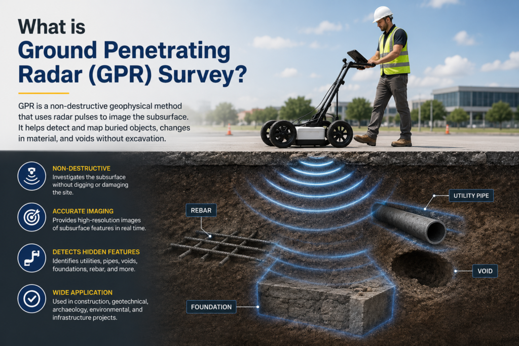
Construction Company

Drone Survey

How ERT Technology Helps in Identifying Rechargeable Points for Rainwater Harvesting

How ERT Technology Helps in Identifying Rechargeable Points for Rainwater Harvesting

Water scarcity has become one of the biggest challenges in India due to rapid urbanization, groundwater depletion, and irregular rainfall patterns. Rainwater harvesting is one of the most effective solutions to restore groundwater levels, but its success depends on identifying the right rechargeable points beneath the surface. This is where ERT (Electrical Resistivity Tomography) technology […]

How ERT Technology Helps in Identifying Rechargeable Points for Rainwater Harvesting Read More »

Drone Survey for IBM Compliance under New MCDR Rules: What Mine Owners Need to Know

Drone Survey for IBM Compliance under New MCDR Rules: What Mine Owners Need to Know

With the implementation of the new MCDR rules, the Indian Bureau of Mines (IBM) has made drone-based survey an essential compliance requirement for mining lease holders. The focus is now on accurate, transparent, and digitally verifiable data to promote scientific and sustainable mining. This blog explains what is required under the new rules, why drone

Drone Survey for IBM Compliance under New MCDR Rules: What Mine Owners Need to Know Read More »

Drone Mapping in India: Advanced Geospatial Solutions

Drone Mapping in India: Advanced Geospatial Solutions by Garud Survey Private Limited

The adoption of drone technology has transformed the way mapping and surveying are carried out across the country. Drone mapping in India is now a preferred solution for infrastructure development, mining, urban planning, and renewable energy projects due to its speed, accuracy, and cost efficiency. By capturing high-resolution aerial data, drone mapping delivers precise geospatial

Drone Mapping in India: Advanced Geospatial Solutions by Garud Survey Private Limited Read More »

Drone Topographic Survey in India: Accurate Land Mapping Solutions

Drone Topographic Survey in India: Accurate Land Mapping Solutions by Garud Survey Private Limited

With the rapid growth of infrastructure, smart cities, and land development projects, the demand for accurate terrain mapping has increased significantly. A drone topographic survey in India has emerged as a modern, efficient, and highly accurate solution compared to traditional land surveying methods. By using advanced UAV technology, topographic surveys can now be completed faster,

Drone Topographic Survey in India: Accurate Land Mapping Solutions by Garud Survey Private Limited Read More »

Drones in Archaeological Exploration: Uncovering the Past from Above

A Trusted Aerial Survey Company in India Transforming UAV Aerial Surveying

Introduction In recent years, UAV aerial surveying in India has emerged as a game-changing technology for industries that require accurate, fast, and cost-effective data collection. From infrastructure development to mining, agriculture, and smart city planning, aerial surveys using drones have redefined how spatial data is captured and analyzed. As a leading aerial survey company in

A Trusted Aerial Survey Company in India Transforming UAV Aerial Surveying Read More »

Drone Survey in Guwahati & Assam: Accurate Mapping Solutions by Garud Survey Private Limited

Drone Survey in Guwahati & Assam: Accurate Mapping Solutions by Garud Survey Private Limited

With rapid infrastructure development, urban expansion, and environmental monitoring projects across Northeast India, the demand for drone survey services in Guwahati and Assam is growing fast. Drone-based surveying offers unmatched accuracy, speed, and cost efficiency compared to traditional ground survey methods. Garud Survey Private Limited provides advanced drone survey services in Guwahati and across Assam,

Drone Survey in Guwahati & Assam: Accurate Mapping Solutions by Garud Survey Private Limited Read More »

RTK vs. PPK vs. Aerial LiDAR: Understanding Accuracy Differences in Drone Surveys

RTK vs. PPK vs. Aerial LiDAR: Understanding Accuracy Differences in Drone Surveys

Drone technology has transformed the surveying and mapping industry, enabling faster, safer, and more accurate data collection. Among these advanced methods, RTK, PPK, and Aerial LiDAR stand out as the leading solutions for high-precision survey projects. However, each method has its own accuracy levels, workflow, and best-use scenarios. In this blog, we explain the accuracy

RTK vs. PPK vs. Aerial LiDAR: Understanding Accuracy Differences in Drone Surveys Read More »

How to Conduct a Groundwater Survey and Ensure Accurate, Reliable Results

How to Conduct a Groundwater Survey and Ensure Accurate, Reliable Results

By Garud Survey Private Limited – India’s Trusted Groundwater & Geophysical Survey Experts Groundwater is one of India’s most valuable natural resources, supporting agriculture, drinking water supply, industrial activities, and rural development. As water scarcity continues to rise across many regions, a scientific and accurate groundwater survey is essential for identifying potential water sources, understanding

How to Conduct a Groundwater Survey and Ensure Accurate, Reliable Results Read More »

How Beginners Can Process Accurate Drone Survey Data: A Complete Step-by-Step Guide

How Beginners Can Process Accurate Drone Survey Data: A Complete Step-by-Step Guide

Drone surveying has transformed how industries collect, analyze, and interpret land and aerial data. From construction and mining to agriculture and smart city planning, drone surveys provide fast, accurate, and cost-effective insights. But for beginners, one major challenge remains: how to properly process drone survey data and ensure accuracy. In this guide, Garud Survey Private

How Beginners Can Process Accurate Drone Survey Data: A Complete Step-by-Step Guide Read More »

Pile Integrity Testing service Low strain Pile integrity testing services

Ensuring Foundation Reliability with Advanced Pile Integrity Testing Services by Garud Survey Private Limited

When it comes to the safety and durability of any structure, the strength of its foundation plays a crucial role. To ensure that deep foundation piles are structurally sound and free from defects, Pile Integrity Testing (PIT) has become an essential part of modern construction practices. At Garud Survey Private Limited, we offer professional Pile

Ensuring Foundation Reliability with Advanced Pile Integrity Testing Services by Garud Survey Private Limited Read More »