The mining and mineral exploration industry has always relied on innovative technologies to improve efficiency, reduce costs, and enhance accuracy. One of the most groundbreaking advancements in recent years is the use of drone magnetic surveys for mineral exploration. By leveraging unmanned aerial vehicles (UAVs) equipped with advanced magnetometers, geologists and mining companies can now gather high-resolution magnetic data faster, safer, and more cost-effectively than traditional ground-based or manned aerial surveys.
What Are Drone Magnetic Surveys?
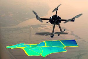
A drone magnetic survey involves flying a drone equipped with a magnetometer over a target area to measure variations in the Earth’s magnetic field. These variations help identify subsurface geological structures, such as iron ore deposits, gold-bearing formations, and other valuable minerals. The magnetometer detects anomalies caused by magnetic minerals, allowing geologists to map potential exploration targets with high precision.
Advantages of Drone Magnetic Surveys in Mineral Exploration
1. Increased Efficiency and Speed
Traditional ground-based magnetic surveys require teams to traverse difficult terrain, often taking weeks or months to cover large areas. In contrast, drones can cover hundreds of square kilometers in a single day, drastically reducing survey time. This rapid data acquisition accelerates decision-making and shortens project timelines.
2. High-Resolution Data Collection
Drones can fly at low altitudes (as low as 30-50 meters) while maintaining consistent survey patterns, resulting in highly detailed magnetic maps. This level of precision is difficult to achieve with manned aircraft or ground surveys, especially in rugged or densely vegetated regions.
3. Cost-Effectiveness
Manned aerial surveys are expensive due to aircraft rental, fuel, and crew costs. Ground surveys also require significant labor and logistical expenses. Drones eliminate many of these costs, offering a more affordable solution without compromising data quality.
4. Access to Challenging Terrain
Mineral exploration often occurs in remote, inaccessible, or hazardous locations—such as dense forests, steep mountains, or post-mining sites. Drones can easily navigate these areas without risking human safety, making them ideal for preliminary exploration in high-risk zones.
5. Environmental and Safety Benefits
Drone surveys minimize ground disturbance, reducing environmental impact compared to traditional methods that may require deforestation or extensive land clearing. Additionally, they eliminate the risks associated with sending personnel into unstable or unexplored regions.
6. Integration with Other Technologies
Drone magnetic data can be combined with other geophysical methods, such as LiDAR, electromagnetic surveys, and multispectral imaging, to create comprehensive geological models. This multi-sensor approach enhances mineral targeting and reduces exploration uncertainty.
Applications in Mineral Exploration
1. Identifying Ore Deposits
Magnetic surveys are particularly effective for locating iron ore, nickel, copper, and rare earth elements, which often produce detectable magnetic signatures. Drones help pinpoint these deposits with greater accuracy than broad-scale surveys.
2. Mapping Geological Structures
Faults, folds, and igneous intrusions can influence mineral deposition. Drone magnetic surveys help map these structures, guiding exploration efforts toward high-potential zones.
3. Brownfield Exploration
In existing mining districts, drones can detect overlooked deposits or extensions of known mineralization, maximizing resource recovery without additional ground disruption.
4. Greenfield Exploration
For unexplored regions, drone surveys provide a fast and low-risk method to assess mineral potential before committing to costly drilling programs.
Challenges and Future Developments
While drone magnetic surveys offer numerous benefits, challenges remain, including:
Battery Life: Limited flight durations require careful mission planning.
Regulatory Restrictions: Drone operations must comply with aviation laws, which vary by country.
Data Processing: Large datasets require advanced software and expertise for interpretation.
Future advancements in drone technology—such as longer battery life, AI-driven data analysis, and improved sensor sensitivity—will further enhance their role in mineral exploration.
Conclusion
Drone magnetic surveys are transforming mineral exploration by providing faster, safer, and more cost-effective solutions than traditional methods. As technology continues to evolve, drones will become an indispensable tool for mining companies seeking to discover new deposits efficiently and sustainably. By embracing this innovation, the mineral exploration industry can unlock new opportunities while minimizing environmental and financial risks.