In a rapidly evolving technological landscape, the future of aerial inspection technology is set to revolutionize industries ranging from construction and infrastructure to agriculture and environmental monitoring. At the heart of this transformation is the convergence of cutting-edge innovations, each contributing to the advancement and efficacy of aerial inspection. In this article, we delve into the intricacies of this burgeoning development, exploring the key trends, advances and implications that are propelling aerial inspection technology to new heights.
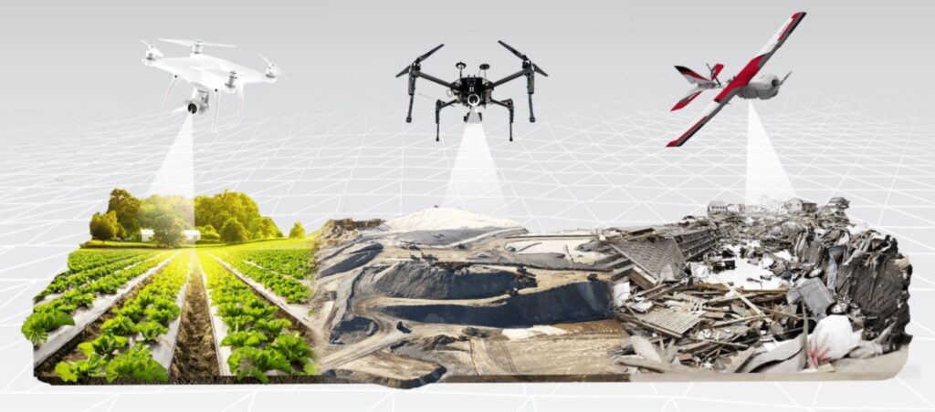
Aerial Drones: Leading Precision and Efficiency
Unmanned Aerial Vehicles (UAVs), commonly known as drones, have emerged as the vanguard of aerial inspection technology. These versatile machines are equipped with high-resolution cameras, LiDAR (Light Detection and Ranging) sensors and other state-of-the-art technologies, which enable them to capture intricate details of structures and landscapes from different angles and altitudes.
Advanced Data Collection
Drones have revolutionized the data collection process, providing an unparalleled level of accuracy and efficiency. Equipped with advanced imaging systems, they can capture high-resolution images and video of remote or inaccessible areas, helping inspectors locate defects, anomalies and potential hazards with unprecedented clarity.
Cost-effectiveness and Time Efficiency
Traditionally, manual inspection processes were not only labor-intensive but also time-consuming. Aerial drones have mitigated these challenges to a great extent by expediting the inspection process. They can cover large areas in a fraction of the time it would take with traditional methods, reducing costs and minimizing disruption to ongoing operations.
Lidar technology: illumination insights from above
LiDAR technology has emerged as a game-changer in aerial surveillance, enabling three-dimensional mapping and analysis of terrain and structures. By emitting laser pulses and measuring the time it takes for them to return, LiDAR sensors create highly accurate and detailed digital elevation models.
Structural Integrity Unveiled
LiDAR’s ability to create detailed 3D models helps assess the structural integrity of buildings, bridges and other critical infrastructure. It detects subtle distortions or changes that may not be visible to the naked eye, facilitating early detection of potential issues and proactive maintenance.
Precision Agriculture
Beyond construction, LiDAR-equipped drones have found applications in precision agriculture. By creating topographic maps of agricultural land, farmers can optimize irrigation, planting and harvesting strategies, resulting in improved crop yields and resource management.
AI-Powered Analytics: Cognitive Advantage
Artificial Intelligence (AI) is the cornerstone of the future of aerial inspection technology, fueling data analysis with unparalleled efficiency and accuracy. Machine learning algorithms can process vast amounts of visual and spatial data, rapidly identifying patterns and anomalies that human observers might overlook.
Automatic Anomaly Detection
AI-powered software can rapidly detect anomalies, defects or structural changes through terabytes of image data collected by drones or satellites. This level of automation not only speeds up the inspection process but also increases the reliability of the findings.
Predictive Maintenance
By analyzing historical inspection data, AI algorithms can predict potential issues and recommend preemptive maintenance measures. This predictive approach prevents costly wear and tear, extends the lifetime of assets and optimizes overall operational efficiency.
Remote sensing and beyond: expanding the horizons
As the field of aerial inspection technology evolves, it enters new areas including remote sensing and augmented reality (AR). These innovations enhance the capabilities of inspectors, giving them access to real-time data and insights even in the most challenging environments.
Remote Sensing Applications
The reach of aerial observation technology extends to disaster response and environmental monitoring. After natural disasters, drones equipped with specialized sensors can assess damage, identify survivors and aid in rescue efforts, as well as keep first responders out of harm’s way.
Augmented Reality Integration
Augmented reality embeds digital information into a real-world environment, thereby enhancing inspectors’ situational awareness and decision-making abilities. The AR glasses can provide real-time data, schematics and annotations, allowing inspectors to identify and resolve issues in real time.
The Road Ahead: Meeting the Challenges and Embracing the Opportunities
Although the future of aerial inspection technology is promising, it also holds challenges. Regulatory hurdles, data privacy concerns and the need for specialized training are all factors that must be addressed as the technology continues to evolve. However, the potential benefits in terms of safety, efficiency and cost-effectiveness are undeniable.
In conclusion, the future of aerial inspection technology is a tapestry woven of threads of innovation, precision and efficiency. Drones, LiDAR technology, AI-powered analytics, remote sensing and augmented reality are shaping the inspection landscape across industries. As these technologies continue to mature and integrate, the sky is the limit for what can be achieved in aerial surveillance.