Drone mapping has emerged as a game-changer in the surveying industry, particularly in areas like land development, construction, agriculture, and environmental monitoring. Garud Survey, a leading survey company, has embraced this cutting-edge technology, transforming the way surveys are conducted. By utilizing drones equipped with advanced sensors and cameras, Garud Survey has been able to provide highly accurate, cost-effective, and time-efficient mapping solutions to its clients.
The Evolution of Drone Mapping
In traditional surveying methods, the process involved lengthy fieldwork, the use of ground-based equipment, and manual data collection. This process was not only time-consuming but also prone to human error. Drone mapping, however, leverages unmanned aerial vehicles (UAVs) to capture high-resolution aerial imagery and geospatial data with minimal ground interference. These UAVs are equipped with specialized cameras, LiDAR (Light Detection and Ranging) sensors, and GPS technology to collect precise topographic and spatial data from the air.
Garud Survey has been at the forefront of adopting drone mapping technology, recognizing its vast potential in enhancing survey accuracy and productivity. By combining drone flight plans, automated data capture, and advanced software, Garud Survey can generate high-quality maps, 3D models, and topographic maps in a fraction of the time compared to traditional methods.
Advantages of Drone Mapping for Garud Survey
High Accuracy and Precision
One of the most significant advantages of drone mapping is the level of accuracy it offers. Drones are equipped with high-end sensors, cameras, and GPS systems that enable them to capture data with millimeter-level precision. Garud Survey has benefited from this accuracy, ensuring that clients receive reliable, highly detailed maps that are perfect for planning, designing, and construction purposes.
Whether conducting land surveys or monitoring large construction projects, Garud Survey relies on the precision of drone mapping to create accurate topographic maps, contour maps, and 3D models, which are essential for making informed decisions.
Faster Data Collection
Traditional surveying methods often require multiple visits to the site, along with extensive manual measurements. Drone mapping dramatically reduces the amount of time spent on-site. With drones, Garud Survey can capture comprehensive data over large areas in just a matter of hours. This has been especially beneficial in projects where time is of the essence, such as infrastructure development or real-time progress monitoring in construction.
Additionally, drones can access hard-to-reach areas that may be hazardous or difficult to navigate by foot. Garud Survey’s ability to cover these areas quickly and efficiently reduces the risk of delays, allowing clients to stay on schedule.
Cost-Effectiveness
Drone mapping eliminates the need for expensive equipment and large crews, resulting in significant cost savings for clients. Traditional surveying required the use of heavy machinery, the hiring of multiple surveyors, and extensive data processing. With drones, Garud Survey reduces labor costs, improves productivity, and minimizes the need for costly manual equipment. The quick data capture and processing also reduce the overall project timeline, resulting in further cost reductions.
Minimal Environmental Impact
Environmental sustainability is an important consideration in modern surveying practices. Drones are much less invasive compared to traditional surveying methods, which may require the use of heavy machinery and vehicles. Drone mapping has minimal environmental impact, reducing soil disruption, noise pollution, and the carbon footprint associated with traditional surveying. This eco-friendly approach aligns with Garud Survey’s commitment to sustainability and environmental stewardship.
Real-Time Data and Monitoring
Drone mapping offers the ability to monitor projects in real time, providing clients with immediate access to up-to-date data. Garud Survey can offer real-time aerial imagery and updates, which is critical for monitoring ongoing construction, land use, and environmental projects. This feature enables clients to quickly identify any issues or discrepancies and make adjustments accordingly, enhancing project management and decision-making.
Applications of Drone Mapping in Garud Survey Projects
Garud Survey utilizes drone mapping for a variety of applications, each benefiting from the precision and efficiency that drone technology brings to the table:
Topographic Surveys: Drones are used to generate accurate topographic maps that represent the contours of the land, essential for design and construction projects.
3D Mapping and Modeling: Drone mapping allows the creation of 3D models of landscapes or structures, providing clients with detailed visual representations for planning and analysis.
Construction Progress Monitoring: Drones can track the progress of construction sites, offering aerial views that help monitor work completed, stockpile volumes, and project timelines.
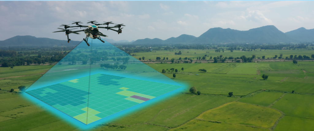
Agriculture and Land Management: Drones can capture high-resolution imagery to assess crop health, monitor land use, and optimize farming practices for improved yields and resource management.
Environmental Surveys: Drones are used for monitoring natural environments, conducting wildlife surveys, and assessing the impact of natural disasters or climate change.
Conclusion
Drone mapping has revolutionized the surveying industry, offering numerous advantages in terms of accuracy, speed, cost, and environmental impact. Garud Survey’s integration of drone technology has significantly enhanced its ability to provide superior surveying solutions across various industries. As drone technology continues to evolve, Garud Survey is well-positioned to maintain its leadership in providing state-of-the-art mapping services that meet the growing demands of modern infrastructure, construction, and environmental management. The future of surveying is undoubtedly aerial, and Garud Survey is embracing this transformation with precision and efficiency.