In the rapidly evolving landscape of geospatial technology, the drone topographic survey has emerged as a game-changer. Traditional surveying methods, while effective, often fall short when it comes to speed, accessibility, and cost-efficiency—especially over large or difficult terrain. Enter Garud Survey Private Limited, one of India’s leading drone service providers, transforming how land and infrastructure projects are planned, executed, and managed.
What is a Drone Topographic Survey?
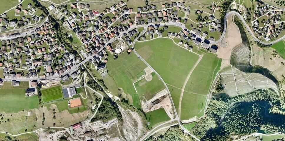
A drone topographic survey uses unmanned aerial vehicles (UAVs) equipped with high-resolution cameras, GPS modules, and LiDAR sensors to collect accurate topographical data from above. These surveys capture thousands of data points quickly, generating 3D maps, elevation models, and contour lines of the terrain. The result is highly detailed geospatial information that’s essential for construction, mining, road planning, irrigation design, and other civil engineering applications.
Unlike conventional surveying—which may take days or weeks—drone topographic survey can cover large areas in a matter of hours with centimeter-level precision.
Why Choose Garud Survey Private Limited?
Garud Survey Private Limited has built a strong reputation as a trusted partner in drone-based surveying solutions. With a deep understanding of geospatial data and years of on-ground experience, the company offers end-to-end services tailored to client needs.
From pre-flight planning and drone data collection to post-processing and GIS integration, Garud Survey ensures the highest standards of accuracy and efficiency in every drone topographic survey project.
Key Benefits of Working with Garud Survey:
Precision & Detail: Advanced UAVs and RTK-GPS technology ensure high-resolution outputs, suitable for even the most complex engineering designs.
Speed & Coverage: Rapid deployment and wide-area coverage reduce project timelines significantly.
Cost Efficiency: Minimized manpower, equipment costs, and rework lead to lower overall expenses.
Accessibility: Difficult or hazardous terrain is no longer a challenge, as drones can safely access areas that are hard to reach on foot.
Applications of Drone Topographic Survey in India
Construction & Infrastructure Planning: Accurate topographic data is essential for road alignment, grading, drainage systems, and foundation design. Garud Survey delivers fast, reliable inputs for civil engineering and urban development projects.
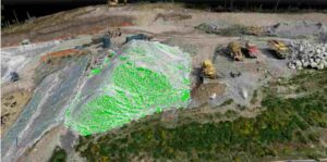
Mining & Quarrying: Regular volumetric measurements and terrain mapping help monitor excavation progress, stockpile volumes, and environmental compliance.
Agriculture & Irrigation: Elevation maps and contour data aid in planning irrigation channels, water harvesting systems, and optimizing land use for farming.
Disaster Management & Environmental Monitoring: In flood-prone or landslide-prone regions, drone topographic survey helps authorities assess risk zones and plan mitigation measures.
Urban Planning & Smart Cities: For municipalities and smart city projects, detailed terrain models support zoning, utility planning, and infrastructure design.
Commitment to Quality and Compliance
Garud Survey Private Limited adheres strictly to DGCA regulations and industry best practices. Every drone topographic survey is conducted by trained pilots and certified GIS analysts. The company also ensures secure data management and transparent communication throughout the project cycle.
Their post-processing capabilities include:
Digital Elevation Models (DEM)
Digital Surface Models (DSM)
Orthomosaic Maps
Contour Generation
3D Modeling
These deliverables are compatible with all major CAD and GIS software, making integration seamless for architects, engineers, and project managers.
The Future of Mapping is in the Sky
As infrastructure and development projects continue to expand across India, the demand for fast, accurate, and cost-effective surveying solutions will only increase. With its forward-thinking approach and deep technical expertise, Garud Survey Private Limited is leading the charge in this transformation.
Whether you’re planning a major construction project, managing land for agriculture, or developing a smart city, a drone topographic survey from Garud Survey is your best bet for success—delivered with precision, speed, and peace of mind.