Drone technology has evolved rapidly over the past few decades, transforming from a niche hobby into a vital tool used across numerous industries. Initially developed for military purposes, drones have become a part of everyday life, with applications from recreational use to critical industrial functions. In this post, we’ll explore how drone technology has progressed, focusing on its industrial applications and innovations like the Garud Survey pushing the boundaries of what drones can achieve.
Early Development: Military Origins to Hobbyist Drones
Drones, or unmanned aerial vehicles (UAVs), originated for military purposes in the 20th century. Initially, they were designed for surveillance, reconnaissance, and target practice, often large, costly, and mainly restricted to military use. However, as technology improved, drones became more accessible and smaller.
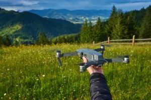
In the early 2000s, drone technology found its way into the hands of hobbyists. Consumer drones were introduced, making it possible for everyday people to fly UAVs for fun. These early drones were basic remote-controlled aircraft, often equipped with cameras, allowing users to capture aerial photographs and videos. This development ignited a wave of interest in drone technology, leading to rapid advancements in both hardware and software over the next few years.
The Rise of Commercial Drones
As technology advanced, drones began to transition from a recreational tool to a commercial asset. One of the first major commercial applications was in photography and videography. Drones equipped with high-definition cameras allowed filmmakers, real estate agents, and even tourism companies to capture stunning aerial footage. Previously, such shots required expensive helicopter rides or complicated setups, but drones made aerial photography far more accessible and affordable.
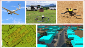
Beyond media and entertainment, drones also began to play an important role in surveying and mapping. Aerial surveys, previously carried out with planes or helicopters, were now being performed by drones, making them more cost-effective, accurate, and efficient. Drones equipped with sensors and GPS technology allow surveyors to collect precise data for mapping large areas or assessing the condition of infrastructure like roads, bridges, and pipelines.
Industrial Applications: Agriculture, Construction, and Mining
One of the most significant areas where drone technology has proven transformative is agriculture. Drones are now widely used in precision farming, where they help monitor crop health, assess soil conditions, and even apply fertilizers and pesticides more efficiently. Drones equipped with multispectral cameras can detect issues such as pest infestations, water stress, and nutrient deficiencies, allowing farmers to address problems before they become widespread.
In addition to agriculture, drones have made a significant impact on industries such as construction and mining. In construction, drones are used for site inspections, progress tracking, and 3D modeling. They provide real-time data that helps project managers monitor construction progress and make informed decisions. Similarly, in mining, drones help survey vast areas, monitor stockpiles, and inspect hazardous zones. They offer a safer and more efficient alternative to traditional methods, especially in challenging environments.
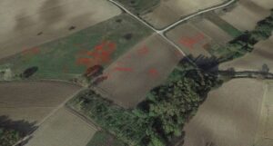
Garud Survey: Innovating Surveying and Mapping with Drones
At the forefront of industrial drone use is Garud Survey, a pioneering initiative that leverages drones for high-precision surveying and mapping. This program has significantly improved how land surveys, environmental monitoring, and infrastructure inspections are conducted.
Garud Survey drones are equipped with advanced sensors and cameras, allowing them to gather accurate data over large areas in a fraction of the time it would take with traditional methods. These drones can create detailed 3D models of landscapes, monitor land use, and track changes over time, making them invaluable for industries such as urban planning, agriculture, and resource management.
By using the Garud Survey, companies and governments can gather critical data more efficiently, improving decision-making and reducing costs. This service is especially useful for large-scale infrastructure projects or environmental monitoring, where traditional methods would be slow, expensive, and less accurate.
Drones in Logistics and Delivery
The logistics and delivery sectors are another area where drones are making waves. Major companies like Amazon and Google have explored drone delivery systems, to provide faster and more efficient delivery services. Drones can bypass traffic, reduce delivery times, and reach remote or hard-to-access areas more easily than traditional delivery vehicles.
Although regulatory and logistical challenges still exist, the potential of drone delivery to revolutionize e-commerce is undeniable. Small packages could be delivered to customers in record time, reducing costs and environmental impact compared to conventional delivery methods.
Challenges and Future Directions
Despite the many advantages, the widespread adoption of drones faces several challenges. Regulatory issues, particularly around airspace management and safety, remain a significant hurdle. Governments around the world are working to create regulations that allow for safe drone operation while addressing concerns around privacy, security, and air traffic control.
Moreover, as drones become more autonomous, there are ethical considerations related to surveillance, data privacy, and the potential for drones to be used maliciously. However, with ongoing advancements in drone technology and regulatory frameworks, the future of drones in various industries looks promising.
Conclusion
The evolution of drone technology has been nothing short of extraordinary. From their origins in military surveillance to their current use in a wide range of industries, drones have become indispensable tools that are transforming sectors like agriculture, construction, and logistics. Innovations like the Garud Survey are enhancing the capabilities of drones in surveying and mapping, offering more accurate and efficient solutions for data collection.
As drones continue to advance in terms of autonomy, AI integration, and data processing, their potential to revolutionize industries and improve efficiency will only increase. With their ability to access hard-to-reach areas, gather real-time data, and provide cost-effective solutions, drones are set to play an even more central role in shaping the future of industrial applications. The sky truly is the limit for what drone technology can achieve.