Introduction
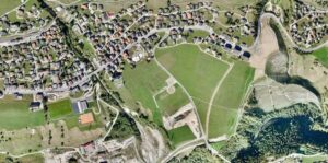
In recent years, UAV aerial surveying in India has emerged as a game-changing technology for industries that require accurate, fast, and cost-effective data collection. From infrastructure development to mining, agriculture, and smart city planning, aerial surveys using drones have redefined how spatial data is captured and analyzed. As a leading aerial survey company in India, Garud Survey Private Limited is at the forefront of this technological transformation, delivering high-precision drone survey solutions across the country.
What Is UAV Aerial Surveying in India?
UAV (Unmanned Aerial Vehicle) aerial surveying involves the use of advanced drones equipped with high-resolution cameras, LiDAR sensors, RTK/PPK systems, and thermal sensors to collect accurate geospatial data. In India, UAV aerial surveying is widely used for:
Topographic and land surveys
Infrastructure and highway projects
Mining and volume estimation
Urban planning and smart cities
Solar, power hooks, and industrial inspections
Disaster management and environmental monitoring
Compared to traditional survey methods, UAV aerial surveying in India offers higher accuracy, faster data collection, and improved safety.
Why Choose Garud Survey Private Limited as Your Aerial Survey Company in India?
Garud Survey Private Limited has built a strong reputation as a reliable and professional aerial survey company in India by combining advanced drone technology with experienced survey professionals.
1. Advanced Drone Technology
We deploy state-of-the-art UAVs integrated with RTK, PPK, LiDAR, and photogrammetry systems to ensure centimeter-level accuracy for all aerial survey projects.
2. DGCA-Compliant Operations
All our UAV aerial surveying operations in India strictly follow DGCA guidelines, ensuring legal compliance, data security, and safe drone operations.
3. Industry-Specific Survey Solutions
Garud Survey Private Limited provides customized aerial survey services tailored for:
Infrastructure & construction
Mining & minerals
Renewable energy (solar & wind)
Railways & highways
Urban development authorities
4. High Accuracy & Fast Turnaround
Our UAV aerial surveying solutions reduce field time significantly and deliver accurate, ready-to-use data outputs such as orthomosaics, DEMs, DSMs, contour maps, and 3D models.
Applications of UAV Aerial Surveying in India
As a trusted aerial survey company in India, Garud Survey Private Limited supports a wide range of applications:
Infrastructure & Smart City Projects
Drone-based aerial surveys provide precise mapping and progress monitoring for roads, bridges, railways, and smart city developments.
Mining & Quarry Surveys
UAV aerial surveying in India is widely used for mine planning, volumetric analysis, stockpile measurement, and compliance reporting.
Land & Topographic Surveys
High-resolution drone mapping ensures accurate land records, boundary demarcation, and topographic analysis.
Solar & Industrial Inspection
Thermal and visual drone surveys help identify faults, heat losses, and maintenance issues in large-scale solar parks and industrial assets.
Disaster Management & Environmental Studies
Aerial surveys play a crucial role in flood mapping, landslide monitoring, forest surveys, and disaster response planning.
Benefits of Choosing UAV Aerial Surveying in India
Cost-effective compared to traditional surveys
Faster data collection and processing
High accuracy and detailed outputs
Improved safety in hazardous locations
Scalable for small to large projects
These advantages make UAV aerial surveying in India the preferred choice for government bodies, private developers, and engineering firms.
Garud Survey Private Limited – Delivering Excellence in Aerial Surveys
With a pan-India operational capability, Garud Survey Private Limited has successfully executed numerous drone survey projects across diverse terrains and industries. Our commitment to accuracy, innovation, and timely delivery positions us as a dependable aerial survey company in India.
We continuously upgrade our UAV technology and data processing workflows to meet evolving industry standards and client requirements.
Conclusion
The future of mapping and surveying lies in drone technology, and UAV aerial surveying in India is rapidly becoming an essential tool for modern development projects. If you are looking for a professional, experienced, and technology-driven aerial survey company in India, Garud Survey Private Limited is your trusted partner.
Contact Garud Survey Private Limited today to experience accurate, efficient, and reliable UAV aerial surveying solutions for your next project.