The adoption of drone technology has transformed the way mapping and surveying are carried out across the country. Drone mapping in India is now a preferred solution for infrastructure development, mining, urban planning, and renewable energy projects due to its speed, accuracy, and cost efficiency. By capturing high-resolution aerial data, drone mapping delivers precise geospatial insights that support better planning and decision-making.
Garud Survey Private Limited is a leading drone mapping company in India, providing reliable and DGCA-compliant UAV mapping services for government and private sector projects nationwide.
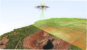
What Is Drone Mapping?
Drone mapping is the process of using unmanned aerial vehicles (UAVs) equipped with advanced sensors and cameras to collect aerial data of land and structures. This data is processed using specialized software to generate:
Orthomosaic maps
Digital Elevation Models (DEM)
Digital Surface Models (DSM)
Contour maps
3D models and GIS-ready outputs
This modern approach ensures faster data collection and higher accuracy compared to traditional ground-based methods.
Growth of Drone Mapping in India
With the rise of smart cities, highway expansion, mining reforms, and renewable energy projects, drone mapping in India has seen significant growth. Government initiatives, supportive drone policies, and technological advancements have further accelerated the adoption of UAV mapping across industries.
Drone mapping is now widely used for large-scale projects where speed, safety, and precision are critical.
Drone Mapping Services by Garud Survey Private Limited
As an experienced drone mapping service provider, Garud Survey Private Limited offers end-to-end UAV mapping solutions tailored to diverse project requirements.
Our Drone Mapping Capabilities Include:
High-resolution aerial mapping
RTK & PPK drone mapping for high accuracy
Topographic and terrain mapping
Corridor mapping for roads, railways, and pipelines
Mining and volume calculation surveys
3D modeling and GIS integration
All surveys are conducted following DGCA guidelines to ensure safety and regulatory compliance.
Applications of Drone Mapping in India
Drone mapping technology is widely used across multiple sectors:
Infrastructure and Construction
Supports planning, progress monitoring, and as-built documentation for roads, bridges, railways, and smart city projects.
Mining and Quarrying
Helps in volume estimation, land profiling, and environmental monitoring with minimal on-ground risk.
Urban Planning and Smart Cities
Provides accurate base maps for zoning, utilities planning, and city development projects.
Renewable Energy Projects
Used for site selection, layout planning, and monitoring of solar parks and wind farms.
Agriculture and Land Management
Assists in land assessment, boundary mapping, and resource planning.
Benefits of Drone Mapping in India
Choosing drone mapping in India offers several advantages:
Rapid data acquisition for large areas
High-accuracy outputs using RTK and PPK technology
Reduced survey costs and manpower
Enhanced safety by minimizing field exposure
Detailed and reliable geospatial data
These benefits make drone mapping an essential tool for modern development projects.
Technology and Accuracy
Garud Survey Private Limited uses advanced UAV platforms combined with RTK, PPK, and optional LiDAR technology to deliver centimeter-level accuracy. Survey outputs are compatible with CAD, GIS, and BIM platforms, ensuring seamless integration into project workflows.
Why Choose Garud Survey Private Limited?
As a trusted drone mapping company in India, we offer:
Experienced drone pilots and survey professionals
Advanced UAV and data processing technology
Pan-India service coverage
Customized mapping solutions
Reliable, accurate, and timely deliverables
Our commitment to quality and innovation sets us apart in the drone survey industry.
Future of Drone Mapping in India
The future of drone mapping in India is promising, with emerging technologies such as AI-based analytics, LiDAR integration, and real-time data processing enhancing mapping capabilities. These innovations will further support large-scale infrastructure and digital governance initiatives.
Garud Survey Private Limited continues to adopt the latest technologies to deliver next-generation drone mapping solutions.
Conclusion
Drone mapping in India has become an indispensable tool for accurate land assessment and infrastructure planning. With advanced technology, skilled professionals, and nationwide reach, Garud Survey Private Limited provides reliable and cost-effective drone mapping services tailored to your project needs.
Contact Garud Survey Private Limited today to experience precise and efficient drone mapping solutions for your next project.