With rapid infrastructure development, urban expansion, and environmental monitoring projects across Northeast India, the demand for drone survey services in Guwahati and Assam is growing fast. Drone-based surveying offers unmatched accuracy, speed, and cost efficiency compared to traditional ground survey methods.
Garud Survey Private Limited provides advanced drone survey services in Guwahati and across Assam, helping government bodies, private companies, and infrastructure developers make better, data-driven decisions.
Why Drone Survey is Essential in Guwahati & Assam
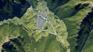
Assam’s diverse geography includes rivers, floodplains, forests, hills, and urban areas. Traditional surveying methods often struggle in such challenging terrain. Drone surveys overcome these limitations by capturing high-resolution aerial data safely and efficiently.
Key Challenges in Assam Addressed by Drone Surveys
Flood-prone river basins (Brahmaputra & tributaries)
Dense vegetation and forest cover
Hilly and inaccessible areas
Rapid urban growth in Guwahati
Large infrastructure and highway projects
Drone technology ensures precise data collection even in these complex environments.
Our Drone Survey Services in Guwahati & Assam
Garud Survey Private Limited offers a wide range of professional drone survey solutions:
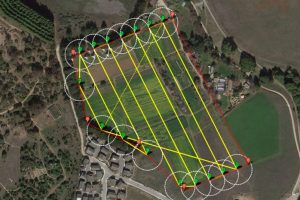
1. Topographic Drone Survey
High-resolution contour mapping
Elevation and slope analysis
Ideal for construction and land development projects
2. Land Survey & Mapping
Accurate land parcel mapping
Boundary demarcation
Support for land record digitization
3. Aerial LiDAR Survey
Penetrates dense vegetation
Generates detailed Digital Terrain Models (DTM)
Best for forest, hilly, and flood-prone areas
4. River & Flood Mapping
River course analysis
Floodplain and erosion mapping
Disaster preparedness and mitigation planning
5. Infrastructure & Construction Survey
Road and highway corridor mapping
Bridge and flyover inspection
Construction progress monitoring
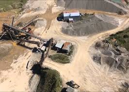
6. Mining & Volumetric Survey
Stockpile volume calculation
Mine planning and monitoring
Accurate cut-and-fill analysis
7. Smart City & Urban Mapping
GIS-based city planning
Utility and drainage mapping
Urban expansion analysis
Accuracy of Our Drone Survey Services
We use RTK, PPK, and Aerial LiDAR drones to ensure survey-grade accuracy:
| Survey Technology | Accuracy Level |
|---|---|
| RTK Drone Survey | 1–3 cm |
| PPK Drone Survey | 2–5 cm |
| Aerial LiDAR Survey | 3–10 cm |
| Standard Photogrammetry | 5–10 cm |
This level of accuracy makes our drone surveys ideal for engineering, government, and large infrastructure projects in Assam.
Benefits of Drone Survey in Guwahati & Assam
1. Faster Data Collection
Drone surveys can cover large areas in hours instead of days.
2. High Accuracy
Centimeter-level precision supports engineering-grade applications.
3. Cost-Effective
Reduced manpower and minimal site visits lower project costs.
4. Safe Operations
Drones eliminate the need for surveyors to work in hazardous or flood-prone zones.
5. Access to Difficult Terrain
Ideal for rivers, forests, hills, and remote locations.
Industries We Serve in Assam
Our drone survey services support multiple sectors:
✔ Infrastructure & highways
✔ Urban development & smart cities
✔ Mining & natural resources
✔ Flood & disaster management
✔ Power, railway & utility projects
✔ Environmental & forest surveys
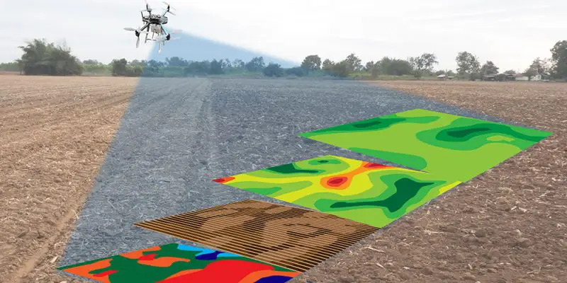
✔ Agriculture & irrigation planning
Garud Survey Private Limited delivers reliable drone survey solutions tailored to Assam’s geographical and environmental conditions.
Why Choose Garud Survey Private Limited in Guwahati & Assam?
Garud Survey Pvt. Ltd. is a trusted name in drone surveying across India, including the Northeast region.
Our Strengths
DGCA-compliant drone operations
Skilled and certified drone pilots
Advanced RTK, PPK & LiDAR drones
High-quality mapping and GIS outputs
Fast turnaround time
PAN-India service coverage
We understand local terrain challenges and provide customized drone survey solutions for Guwahati and Assam.
Applications of Drone Survey in Guwahati
City road planning
Riverbank protection projects
Flood risk assessment
Real estate and land development
Industrial and logistics parks
Smart city and GIS projects
Drone surveys help authorities and developers plan smarter and build safer.
Conclusion
Drone surveying is transforming how mapping and data collection are done in Guwahati and Assam. With advanced drone technology, projects can be completed faster, more accurately, and at a lower cost.
If you are looking for professional drone survey services in Guwahati or anywhere in Assam, trust Garud Survey Private Limited for reliable, accurate, and DGCA-compliant solutions.