Introduction
In the world of modern technology, LiDAR (Light Detection and Ranging) has emerged as a game-changing tool that has transformed various industries from urban planning and forestry to archeology and autonomous vehicles. This revolutionary surveying method uses laser beams to measure distances, creating incredibly detailed and accurate 3D maps of landscapes and objects. In this article, we’ll delve deeper into the fascinating world of LiDAR surveys, exploring their applications, benefits, and their impact on shaping our future.
Understanding LiDAR
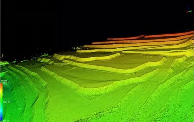
LiDAR, a remote sensing technology, works by emitting a laser pulse that bounces off surfaces and returns to the sensor. By measuring the time it takes for the pulses to return, the system calculates the distance between the sensor and the object or surface. This data is then processed to generate a highly accurate 3D representation of the surveyed area.
LiDAR Surveying Applications
- Mapping and Cartography: LiDAR surveys have revolutionized the field of cartography. Traditional mapping techniques can be time consuming and lack accuracy in complex terrain. On the other hand, LiDAR can quickly and accurately map vast areas, including dense forests, mountainous landscapes, and urban environments. This data is invaluable for urban planning, infrastructure development and disaster management.
- Environmental Monitoring: LiDAR surveys help in monitoring environmental changes over time. From tracking deforestation and analyzing erosion patterns to estimating glacier retreat, LiDAR provides accurate data for scientists to understand environmental changes and implement conservation strategies.
- Archeology and Cultural Heritage: LiDAR makes it easier to uncover the secrets of the past. Archaeologists can now uncover ruins, settlements and even ancient cities hidden under dense vegetation. This non-invasive technique helps preserve cultural heritage while revealing new insights into our history.
- Flood Modelling: Accurate flood modeling is important for disaster preparedness. LiDAR survey can create detailed elevation maps of flood-prone areas, increasing the accuracy of flood forecasting and assisting in the development of effective evacuation plans.
- Autonomous Vehicles: LiDAR plays an important role in the development of autonomous cars. By providing real-time, high-resolution 3D maps of the surroundings, LiDAR enables autonomous vehicles to navigate safely and make quick decisions, reducing the risk of accidents.
Advantages of LiDAR Surveying
- Accuracy: LiDAR offers unparalleled accuracy, often claiming centimeter-level accuracy. This level of detail is essential for applications such as construction, where precise measurements are critical.
- Efficiency: LiDAR surveys can cover vast areas in a fraction of the time it takes with traditional methods. This efficiency not only saves time and resources but also allows for more frequent updates of mapping data.
- Versatility: Whether it’s analyzing forests, coastal erosion, or city scenes, LiDAR can adapt to different terrains and environments, making it a versatile tool across many industries.
- Non-invasive nature: LiDAR is a non-intrusive technology that can collect data without physically touching the scanned surfaces. This makes it ideal for fragile ecosystems, historical sites and places where disturbing the environment is undesirable.
The Future of Lidar
As the technology continues to develop, LiDAR is becoming more accessible and affordable. This access opens up opportunities for startups, researchers and small organizations to harness the power of LiDAR for their projects. Additionally, advances in data processing algorithms have made it easier to extract meaningful insights from the vast datasets generated by LiDAR surveys.
Conclusion
LiDAR surveys are pushing the boundaries of what is possible in a variety of fields, from archeology to urban planning. With their unmatched accuracy, efficiency and versatility, LiDAR technologies are changing the way we interact with and understand our world. As we continue to uncover its potential, LiDAR is poised to shape the future of exploration, innovation and sustainability.