In recent years, drones have become an invaluable tool for various industries, from agriculture to construction, and now, archaeology is tapping into this transformative technology. Drones are revolutionizing how archaeological surveys are conducted, offering speed, precision, and unprecedented access to landscapes previously challenging to explore. Here at Garud Survey Private Limited, we are excited about how drones reshape the approach to discovering, documenting, and preserving ancient history.
A New Era for Archaeological Surveys
Traditional archaeological surveys often involve months—or even years—of groundwork, careful excavation, and detailed mapping. Drones, however, are now providing archaeologists with a faster and less invasive way to gather critical data from historical sites. These unmanned aerial vehicles (UAVs) allow researchers to scan vast areas in a fraction of the time required by conventional methods, all while preserving the integrity of fragile sites.
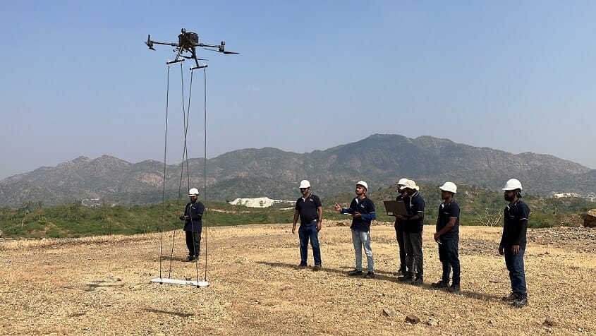
Drones are instrumental in remote areas where rugged landscapes, dense vegetation, or political instability may hinder ground access. Equipped with cameras and advanced sensors, drones capture high-resolution images and produce 3D maps that enable archaeologists to examine the topography and features of a site with exceptional clarity. At Garud Survey Private Limited, we use cutting-edge drone technology to offer innovative surveying solutions tailored to archaeology.
Advantages of Drones in Archaeology
The versatility and functionality of drones make them uniquely suited for archaeological applications. Here are some key benefits they provide to modern archaeology:
- Efficiency and Speed: Drones significantly reduce the time required for site surveys. By flying over an area, drones can collect detailed images and generate maps that would typically take days, if not weeks, to compile. This is particularly beneficial when assessing large or remote sites where ground access is limited.
- Cost-Effectiveness: Traditional surveying and excavation are costly due to the manpower, tools, and transport involved. Drones offer a cost-efficient alternative by reducing the need for extensive equipment and labor. This affordability allows archaeologists to explore more sites, even those previously deemed economically unfeasible.
- Enhanced Data Collection: Drones come equipped with advanced imaging technologies like LiDAR (Light Detection and Ranging) and photogrammetry. These tools provide detailed, 3D digital models that reveal terrain, structures, and artifacts buried beneath the surface. This level of detail not only supports discovery but also aids in planning precise excavations without disturbing the surrounding environment.
- Reduced Environmental Impact: Traditional excavation techniques can be invasive, often disturbing delicate landscapes and artifacts. Drones, however, allow archaeologists to study sites from above, preserving fragile ecosystems and avoiding potentially damaging excavation. This non-invasive approach helps maintain the integrity of archaeological sites for future study and conservation.
- Uncovering Hidden Patterns and Sites: Drones enable aerial views of landscapes, allowing archaeologists to identify patterns and features not visible from the ground. The use of infrared and multispectral imaging can help reveal vegetation differences indicative of buried structures, roads, or settlements. This is invaluable in pinpointing undiscovered archaeological sites, which can then be explored further through targeted excavation.
How Drones Are Being Used in Archaeology Today
Drones are already making a significant impact in the field of archaeology worldwide. At Garud Survey Private Limited, we employ state-of-the-art UAVs with capabilities for high-resolution mapping, multispectral imaging, and LiDAR scanning, offering precise and customizable surveying solutions. Here are a few ways drones are being utilized in archaeological projects:
- Mapping and Documentation: Drones are ideal for creating digital maps and photogrammetric models of ancient ruins, forts, and landscapes. Archaeologists can visualize how a site once appeared, assisting in both historical understanding and public presentations.
- Discovering New Sites: The aerial perspective and advanced sensors of drones enable archaeologists to spot previously undiscovered sites. In forested regions or mountainous terrains, drones can fly low enough to capture areas otherwise invisible from traditional satellite imagery, leading to fresh archaeological discoveries.
- Monitoring and Preservation: Historical sites are vulnerable to natural elements, human activity, and environmental changes. Drones provide a reliable means of monitoring these sites over time, allowing archaeologists to document changes and ensure proper conservation. UAVs can track erosion, encroachment, and other damaging processes, providing vital data that helps in preserving cultural heritage.
- Virtual Reconstructions: High-quality 3D models generated by drone imagery enable the creation of virtual reconstructions of ancient sites, accessible to researchers and the public alike. These digital reconstructions support interactive learning and can help raise awareness of cultural heritage, preserving its legacy even if the physical site deteriorates over time.
The Future of Drones in Archaeology
As drone technology continues to advance, the possibilities for their application in archaeology will only expand. With more efficient UAVs, improved imaging technologies, and AI-powered data analysis, drones are expected to play an even larger role in uncovering our shared history. The integration of AI with drone imagery, for example, could assist archaeologists in automatically identifying patterns or anomalies in vast datasets, further accelerating the pace of discovery.
At Garud Survey Private Limited, we are dedicated to staying at the forefront of drone technology to provide archaeologists with powerful tools for uncovering history. As we continue to push the boundaries of what drones can do, we look forward to helping archaeologists across the globe reveal the mysteries of the past.
Conclusion
The role of drones in archaeological surveys marks a profound shift in how we explore, document, and preserve historical sites. By offering an efficient, cost-effective, and less intrusive means of data collection, drones have transformed archaeological practices, making it possible to uncover and protect cultural heritage with greater ease than ever before. As technology advances, the synergy between drones and archaeology will continue to grow, creating new pathways to understand the civilizations that came before us.
Garud Survey Private Limited is proud to be a part of this exciting field, providing cutting-edge drone services that make a difference in preserving history. We look forward to helping archaeologists unlock more secrets of the past and bring humanity’s ancient stories to light for generations to come.


