The concept of smart cities is no longer a futuristic vision but a present-day reality. As urban areas continue to grow, the need for efficient and sustainable urban planning becomes increasingly critical. Drone surveys are emerging as a powerful tool in this domain, offering unparalleled advantages in data collection, analysis, and visualization.
Accurate and Comprehensive Data Collection
One of the primary benefits of using drones in urban planning is their ability to collect accurate and comprehensive data. Traditional methods of data collection, such as ground surveys and satellite imagery, often fall short in terms of resolution and detail. Drones, equipped with high-resolution cameras and advanced sensors, can capture detailed images and topographic data with remarkable precision. This data is invaluable for creating accurate 3D models and maps, which are essential for effective urban planning.
Cost and Time Efficiency
Urban planning projects often involve extensive surveys that can be both time-consuming and expensive. Drones significantly reduce the time and cost associated with these surveys. They can cover large areas quickly, capturing data that would take weeks or even months to collect using traditional methods. This efficiency allows urban planners to make faster, more informed decisions, accelerating the development process.
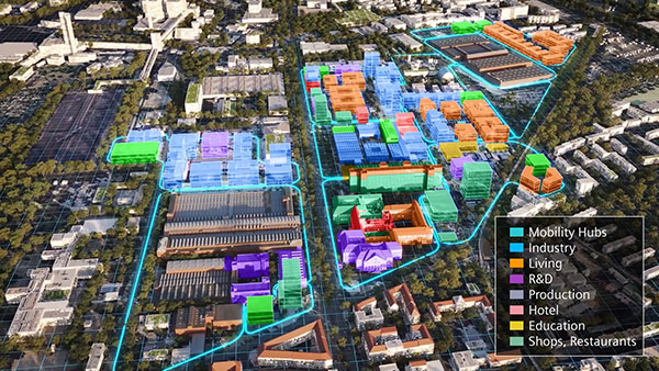
Enhanced Visualization and Simulation
Drones provide urban planners with the ability to create detailed 3D models and simulations of proposed developments. These models can be used to visualize the impact of new infrastructure, assess potential challenges, and make necessary adjustments before construction begins. This level of visualization is particularly useful for stakeholder engagement, as it allows for a clearer understanding of the project and its implications.
Environmental and Social Impact Assessment
Drones are also instrumental in conducting environmental and social impact assessments. They can monitor air quality, track changes in land use, and assess the impact of construction activities on local communities. This data is crucial for ensuring that urban development projects are sustainable and socially responsible.
Traffic and Infrastructure Management
Smart cities rely on efficient traffic and infrastructure management to function effectively. Drones can be used to monitor traffic patterns, identify bottlenecks, and assess the condition of existing infrastructure. This information can be used to optimize traffic flow, plan new transportation routes, and prioritize maintenance activities.
Public Safety and Emergency Response
In addition to urban planning, drones play a vital role in public safety and emergency response. They can be deployed to assess damage after natural disasters, monitor large public events, and support search and rescue operations. This capability enhances the overall resilience of smart cities, ensuring that they are better prepared to handle emergencies.
Conclusion
Drone surveys are revolutionizing the field of urban planning, offering a range of benefits that support the development of smart cities. From accurate data collection and cost efficiency to enhanced visualization and environmental assessment, drones are proving to be an indispensable tool for urban planners. As technology continues to evolve, the role of drones in smart city development is set to expand, paving the way for more sustainable, efficient, and resilient urban environments.