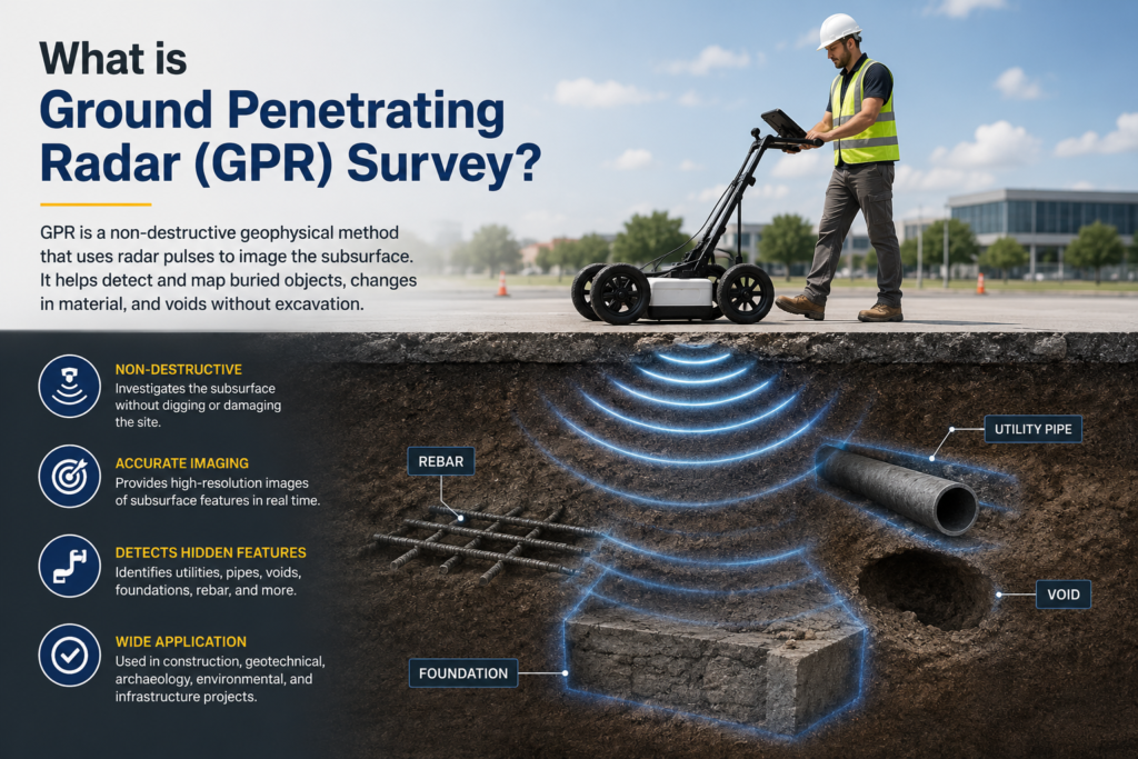
In today’s fast-growing infrastructure and construction industry, accurate underground mapping has become essential before starting any excavation or engineering project. One of the most advanced technologies used for subsurface investigation is Ground Penetrating Radar (GPR) Survey. This non-destructive surveying method helps detect underground utilities, structures, voids, pipelines, cables, and other hidden objects without digging the ground.
Garud Survey is a leading drone and geospatial solutions company in India that provides advanced GPR survey services for construction, infrastructure, mining, smart city projects, and utility mapping.
Understanding Ground Penetrating Radar (GPR)
Ground Penetrating Radar, commonly known as GPR, is a geophysical method that uses high-frequency electromagnetic waves to scan and image the subsurface of the earth. The system transmits radar pulses into the ground, and when these waves encounter different materials or buried objects, they reflect back to the receiver.
The collected data is then processed to create detailed underground maps and profiles. GPR technology is widely used because it is fast, accurate, and does not damage the surface during the survey process.
How Does a GPR Survey Work?
A GPR system mainly consists of three components:
- Transmitter antenna
- Receiver antenna
- Data processing unit
The transmitter sends electromagnetic signals into the ground. When these signals hit underground objects like pipes, cables, concrete layers, rocks, or cavities, they bounce back to the receiver. The reflected signals are analyzed to determine the depth, size, and location of underground features.
The survey can be performed on roads, concrete surfaces, soil, bridges, airports, railways, and construction sites.
Importance of GPR Survey
Ground Penetrating Radar surveys are becoming increasingly important in modern engineering and infrastructure projects. Before excavation or drilling, it is necessary to understand what lies beneath the ground to avoid costly damages and safety risks.
GPR surveys help project managers and engineers:
- Detect underground utilities
- Prevent accidental damage to pipelines and cables
- Reduce excavation risks
- Save time and project costs
- Improve safety on construction sites
- Support accurate planning and design
Applications of Ground Penetrating Radar Survey
GPR surveys are used in various industries due to their accuracy and versatility.
1. Utility Detection
One of the most common uses of GPR is detecting underground utilities such as:
- Water pipelines
- Gas pipelines
- Electrical cables
- Fiber optic cables
- Sewer lines
This helps avoid accidental utility damage during construction work.
2. Road and Highway Inspection
GPR technology is used to inspect roads and highways by identifying:
- Pavement thickness
- Underground voids
- Moisture content
- Structural defects
This helps in road maintenance and infrastructure planning.
3. Concrete Scanning
In construction projects, GPR is used for concrete scanning to locate:
- Rebar placement
- Post-tension cables
- Voids and cracks
- Embedded conduits
This is highly useful before drilling or cutting concrete structures.
4. Archaeological Investigations
Archaeologists use GPR surveys to detect buried structures, ancient artifacts, and historical remains without excavation.
5. Mining and Geological Studies
GPR helps mining companies identify underground formations, fractures, and cavities, improving operational safety and efficiency.
6. Bridge and Tunnel Inspection
Bridges and tunnels require regular inspections to maintain safety. GPR surveys help identify internal damages, corrosion, and structural weaknesses.
Advantages of GPR Survey
Ground Penetrating Radar technology offers several advantages compared to traditional underground investigation methods.
Non-Destructive Method
GPR surveys do not require digging or damaging the surface, making them environmentally friendly and cost-effective.
Fast and Accurate Results
Large areas can be scanned quickly with high accuracy, reducing project delays.
Real-Time Data Collection
The survey provides instant underground imaging, allowing engineers to make quick decisions.
Safe Technology
GPR uses electromagnetic waves and does not involve harmful chemicals or radiation.
Cost Savings
By preventing accidental utility strikes and reducing unnecessary excavation, GPR surveys help save significant project costs.
Limitations of GPR Survey
Although GPR is highly effective, it also has certain limitations.
- Performance may reduce in highly conductive soils like clay
- Detection depth depends on soil conditions
- Moisture can affect signal penetration
- Complex underground environments may require advanced data interpretation
Despite these limitations, GPR remains one of the most reliable underground survey technologies available today.
Why Choose Garud Survey for GPR Services?
Garud Survey provides professional Ground Penetrating Radar survey services across India using advanced equipment and experienced survey experts.
The company specializes in:
- Underground utility mapping
- Infrastructure inspection
- Construction site investigation
- Smart city surveys
- Industrial inspection
- Railway and highway surveys
Garud Survey focuses on delivering accurate geospatial data with modern technology solutions that improve project efficiency and safety.
Future of Ground Penetrating Radar Survey
With rapid urban development and increasing infrastructure projects, the demand for advanced underground surveying solutions is growing rapidly. GPR technology is expected to become even more advanced with AI-based data processing, 3D mapping, and drone integration.
Industries are increasingly adopting GPR surveys because they reduce risks, improve planning, and support sustainable development practices.
Conclusion
Ground Penetrating Radar (GPR) Survey is a modern, efficient, and non-destructive technology used for underground investigation and utility detection. It plays a vital role in construction, infrastructure development, mining, archaeology, and industrial projects.
By providing accurate underground data without excavation, GPR surveys help improve safety, reduce costs, and enhance project planning. Companies like Garud Survey are helping industries across India adopt advanced surveying technologies for smarter and safer project execution.
As technology continues to evolve, GPR surveys will remain an essential part of modern geospatial and engineering solutions.