Planning a highway is not simply about deciding where a road should be built. The selected alignment must work with the terrain, drainage, existing infrastructure, land requirements, geological conditions, environmental constraints and engineering design requirements. This is why an Engineering Survey for Highway Alignment in India is an essential part of highway planning and development.
An engineering survey provides the physical and spatial information required to compare possible routes, understand ground conditions and develop an alignment that is practical for construction and long-term operation. Modern highway projects increasingly combine conventional surveying with GNSS, drone mapping, LiDAR, GIS, photogrammetry and other investigation techniques.
For infrastructure developers, EPC contractors, highway consultants and government agencies, choosing the right survey methodology can significantly improve the quality of design information available before construction begins.
What Is an Engineering Survey for Highway Alignment?
An engineering survey for highway alignment is a systematic process of collecting and analysing information about a proposed road corridor before the alignment is finalised.
The survey may examine:
- Terrain and elevation
- Existing roads and structures
- Rivers, streams and drainage features
- Land-use patterns
- Settlements and built-up areas
- Slopes and terrain constraints
- Soil and geological conditions
- Existing utilities
- Property and land boundaries
- Environmental constraints
- Crossings and potential structures
- Existing transportation networks
The objective is not merely to produce a map. The collected information helps highway engineers and planners compare route alternatives and develop engineering solutions based on actual site conditions.
For large corridors, modern aerial surveying technologies can complement ground-based GNSS, total station and levelling methods, creating a more comprehensive picture of the project area.
Why Engineering Survey Is Important for Highway Alignment
Highway alignment influences several aspects of a road project, including construction requirements, earthwork, drainage, land acquisition, structures and operational safety.
A poorly investigated corridor can create problems later in the project. For example, an alignment may encounter unexpected drainage conditions, steep terrain, utilities, settlements or difficult geological conditions that were not adequately identified during planning.
A well-planned survey helps engineering teams:
- Understand existing terrain
- Compare alternative routes
- Identify physical constraints
- Estimate preliminary earthwork
- Analyse drainage conditions
- Plan crossings and structures
- Develop topographic information
- Support detailed engineering design
- Improve coordination between survey and design teams
The Indian Roads Congress highlights the importance of considering overall transportation cost together with construction, maintenance, road-user, social and environmental requirements during route selection and alignment improvement.
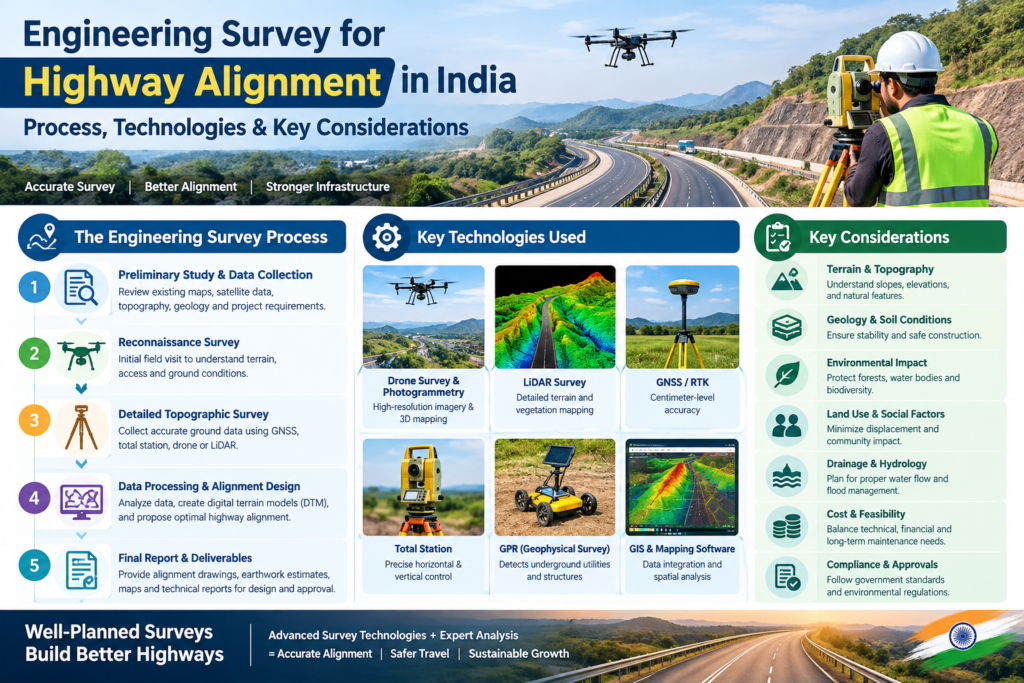
Stages of Engineering Survey for Highway Alignment
Highway alignment surveys traditionally progress through a series of stages. The exact scope can vary depending on project type, terrain, authority requirements and project specifications.
1. Map Study
Map study is generally the initial desk-based activity.
Available topographic maps, satellite imagery, digital elevation information, existing road maps and other relevant spatial datasets can be reviewed to understand the broad characteristics of the proposed corridor.
At this stage, planners may identify:
- Possible route corridors
- Major rivers and water bodies
- Hills and valleys
- Existing highways and roads
- Settlements
- Protected or environmentally sensitive areas
- Major infrastructure
- Potential engineering constraints
The purpose is to narrow down feasible alternatives before extensive fieldwork is undertaken.
2. Reconnaissance Survey
After the initial map study, a reconnaissance survey provides field-level understanding of the shortlisted alternatives.
Survey professionals and engineers inspect the corridor to verify important features identified during desk studies and identify additional site conditions.
The reconnaissance stage may examine:
- Terrain characteristics
- Existing road conditions
- River and stream crossings
- Drainage patterns
- Soil and geological observations
- Settlement patterns
- Existing utilities
- Accessibility
- Potential construction constraints
Drone imagery can also be useful for rapidly reviewing large or difficult-to-access areas.
3. Preliminary Survey
The preliminary survey involves more detailed data collection along the shortlisted alignment alternatives.
Depending on project requirements, it may include:
Topographic Survey:
Collection of ground elevations, contours, natural features and man-made features.
GNSS/DGPS Survey:
Establishment of horizontal and vertical control and collection of accurate spatial coordinates.
Drone Photogrammetry:
Aerial imagery can be processed into orthomosaics, elevation models and 3D datasets.
LiDAR Survey:
Aerial LiDAR can provide dense three-dimensional information over extensive corridors, particularly where terrain complexity or vegetation makes conventional mapping more challenging.
Geotechnical Investigation:
Ground investigations help understand soil, rock and foundation conditions relevant to the proposed road.
Hydrological Investigation:
Drainage patterns, watercourses and flood-related considerations can influence alignment and structure planning.
The preliminary survey allows alternatives to be compared using engineering and environmental information rather than relying only on visual inspection.
4. Final Location and Detailed Survey
Once the preferred alignment is selected, a detailed survey is conducted to support engineering design and construction planning.
This stage may involve:
- Establishing survey control
- Setting out the selected centreline
- Detailed levelling
- Longitudinal profiling
- Cross-section surveys
- Existing road surveys
- Drainage and watercourse surveys
- Structure location surveys
- Utility identification
- Land and property information
- Detailed topographic mapping
The final survey information becomes an important input for road geometry, earthwork calculations, drainage design and other engineering activities.
Key Data Required for Highway Alignment
An effective engineering survey should provide more than basic elevation points. Highway designers often need an integrated understanding of the corridor.
Topographic Information
Topographic information shows the existing ground surface and important natural and artificial features.
Typical outputs may include:
- Contours
- Spot levels
- Digital Terrain Models
- Digital Elevation Models
- Breaklines
- Existing structures
- Roads
- Drainage features
- Terrain slopes
Terrain and Elevation Data
Elevation information is particularly important when evaluating gradients, cut-and-fill requirements, valleys, ridges and other terrain constraints.
For long corridors, aerial LiDAR can provide dense three-dimensional information that can subsequently be classified and modelled into engineering datasets.
Drainage Information
Water movement should be considered early in highway planning.
Survey data can help identify:
- Natural drainage channels
- Low-lying areas
- Streams
- Rivers
- Depressions
- Existing culverts
- Potential water accumulation zones
This information can support the planning of culverts, bridges, side drains and other drainage infrastructure.
Existing Infrastructure and Utilities
Highway corridors often interact with existing infrastructure such as:
- Roads
- Buildings
- Railway crossings
- Transmission lines
- Pipelines
- Water networks
- Telecommunications infrastructure
- Industrial facilities
Identifying these features early can help designers understand potential alignment constraints and crossing requirements.
Role of Modern Technology in Highway Engineering Surveys
Technology has significantly expanded the capabilities of engineering survey teams.
GNSS and RTK
GNSS-based surveying can establish accurate horizontal and vertical control and support detailed field measurements.
RTK workflows can provide high-precision positioning when suitable correction services and field conditions are available.
Total Station
Total stations remain valuable for detailed ground measurements, setting out, control surveys and locations where direct observations are required.
Drone Photogrammetry
Drone photogrammetry uses overlapping aerial images to generate spatial datasets such as:
- Orthomosaics
- Point clouds
- Surface models
- 3D models
- Contour information
It can be particularly useful for rapidly mapping construction sites, road corridors and large land areas.
Aerial LiDAR
Aerial LiDAR uses laser measurements to generate dense three-dimensional point clouds.
For highway projects, LiDAR can support:
- Corridor mapping
- Terrain modelling
- Alignment analysis
- Cross-section generation
- Longitudinal profiles
- Drainage analysis
- Earthwork assessment
- Slope analysis
- Bridge and culvert planning
A major advantage is the ability to acquire extensive spatial information efficiently while reducing dependence on point-by-point ground measurements for every part of a large corridor.
For detailed information about the role of LiDAR in highway alignment and engineering design, readers can refer to the relevant Aerial LiDAR Survey for Highway Alignment & Engineering Design service page.
How Engineering Survey Supports Highway Alignment Decisions
The purpose of collecting survey data is ultimately to support better engineering decisions.
Alternative Route Comparison
Several possible alignments may initially appear feasible. Survey data helps compare alternatives based on terrain, drainage, structures, land requirements and other constraints.
Cut-and-Fill Assessment
Terrain models allow engineers to examine elevation differences and estimate preliminary excavation and embankment requirements.
Slope Analysis
Steep terrain can affect road geometry, earthwork, retaining structures and construction feasibility. Detailed elevation data helps identify challenging sections.
Drainage Planning
Understanding natural water flow is essential for designing drainage infrastructure and reducing the risk of water accumulation and erosion.
Bridge and Culvert Planning
Survey information around rivers, streams and drainage channels supports preliminary planning of bridges and culverts.
Land Acquisition Planning
Alignment information combined with appropriate cadastral and land records can help identify parcels potentially affected by the proposed corridor.
Engineering Survey Company India: How to Choose the Right Provider
Selecting an Engineering Survey Company India for a highway project requires more than comparing equipment lists or prices.
Project owners and consultants should evaluate whether the survey provider can understand the engineering objective behind the data collection.
Important selection criteria include:
Technical Capability
The company should have access to suitable technologies such as GNSS, total stations, drones, LiDAR, GIS and relevant processing systems according to project requirements.
Survey and Processing Expertise
Data acquisition is only one part of the process. Point-cloud processing, terrain modelling, quality control and engineering-ready deliverables are equally important.
Understanding of Highway Projects
A provider familiar with road and corridor projects can better understand requirements such as alignment mapping, cross-sections, profiles, drainage features, structures and terrain analysis.
Quality Control
Ask how control points, check points, coordinate systems, accuracy requirements and data validation will be handled.
Deliverable Compatibility
Before awarding a project, clarify whether the final data will be supplied in the formats required by the design consultant and engineering team.
Possible outputs may include:
- CAD drawings
- GIS layers
- Point clouds
- DTM/DEM
- Contours
- Orthomosaics
- Cross-sections
- Longitudinal profiles
- 3D models
- Survey reports
Role of an Engineering Survey Consultant India
An Engineering Survey Consultant India can contribute at the planning, investigation and design-support stages of infrastructure projects.
Rather than treating surveying as an isolated field activity, a consultant can help connect:
Site conditions → Survey data → Spatial analysis → Engineering interpretation → Design inputs
This approach is especially useful for complex highway projects where terrain, drainage, structures, utilities and land constraints must be considered together.
The consultant or survey team should also coordinate with highway designers, geotechnical specialists, hydrologists, environmental professionals and project authorities wherever required by the project scope.
Engineering Survey vs Conventional Surveying
Engineering survey should not be viewed as a complete replacement for conventional field surveying.
Instead, modern highway projects often benefit from a hybrid survey approach.
| Survey Technology | Typical Role in Highway Projects |
|---|---|
| GNSS/RTK | Control, positioning and detailed field survey |
| Total Station | Precise ground measurements and setting out |
| Drone Photogrammetry | Aerial mapping, orthomosaics and 3D modelling |
| Aerial LiDAR | Dense corridor elevation and terrain mapping |
| GIS | Spatial analysis and integration |
| GPR | Underground utility and subsurface investigation |
| Geotechnical Survey | Soil and ground-condition assessment |
The appropriate combination depends on project objectives, terrain, accuracy requirements, corridor size, accessibility and deliverables.
What Are the Typical Deliverables?
Deliverables should be agreed before the survey begins because the required outputs depend on the engineering stage and project specifications.
Typical highway engineering survey deliverables can include:
- Survey control network
- Topographic maps
- Digital terrain models
- Digital elevation models
- Classified point clouds
- Orthomosaic imagery
- Contour maps
- Longitudinal profiles
- Cross-sections
- Drainage and watercourse information
- Existing infrastructure mapping
- GIS datasets
- CAD drawings
- Survey reports
- 3D terrain models
For large highway or NHAI-related projects, the exact technical specifications, accuracy requirements, control procedures and deliverables should always be established according to the applicable project documents and authority requirements.
Why Data Quality Matters in Highway Projects
A survey is only useful when its data is reliable and suitable for the intended engineering purpose.
Data quality can be influenced by:
- Survey control
- GNSS conditions
- Sensor quality
- Flight planning
- Terrain
- Vegetation
- Ground conditions
- Point-cloud processing
- Classification
- Quality-control procedures
- Coordinate reference systems
- Verification and check points
A professional workflow therefore needs both data acquisition and data validation.
For large infrastructure corridors, integrating multiple survey technologies can also provide useful cross-checks and improve confidence in the resulting engineering datasets.
Future of Engineering Surveys for Highway Alignment
The future of highway surveying is increasingly connected with digital engineering.
LiDAR, drones, GIS, BIM, artificial intelligence, automated feature extraction and digital-twin workflows are creating new possibilities for managing corridor information.
Future workflows may increasingly connect survey data directly with:
- 3D highway design
- BIM environments
- Digital twins
- Automated terrain classification
- Change detection
- Construction monitoring
- Asset management
- Infrastructure maintenance
This means engineering surveys are evolving from simple measurement exercises into comprehensive digital information systems for infrastructure projects.
How Garud Survey Supports Highway Surveying Requirements
Garud Survey Private Limited provides surveying and geospatial solutions using technologies including LiDAR, drone surveying, GNSS, GIS and photogrammetry.
For highway-related applications, these technologies can support corridor mapping, terrain modelling, alignment studies, engineering data generation and other project-specific requirements.
If your project requires detailed corridor mapping or Aerial LiDAR Survey for Highway Alignment & Engineering Design, the appropriate survey methodology should be selected according to project scope, terrain, accuracy requirements and required engineering outputs.
Conclusion
An Engineering Survey for Highway Alignment in India provides the technical foundation for understanding a proposed road corridor before major design and construction decisions are made.
From map study and reconnaissance to preliminary investigation and final detailed survey, each stage contributes important information about terrain, drainage, infrastructure, utilities, land and other alignment constraints.
Modern technologies such as GNSS, drones, LiDAR, photogrammetry and GIS can complement conventional surveying and provide engineering teams with richer spatial information across large highway corridors.
For project owners, consultants and contractors, the most effective approach is not simply to select the newest technology. It is to select the right combination of survey methods, quality controls and deliverables for the engineering objective.
For highway projects requiring detailed aerial terrain and corridor information, explore Garud Survey’s Aerial LiDAR Survey for Highway Alignment & Engineering Design services and discuss the survey requirements for your project.
FAQ
1. What is an engineering survey for highway alignment?
It is the systematic collection and analysis of terrain, topographic, drainage, infrastructure, geological and other site information needed to evaluate and develop a suitable highway alignment.
2. What are the main stages of an engineering survey for highway alignment?
The commonly described stages are map study, reconnaissance survey, preliminary survey, and final location and detailed survey. The exact scope can vary according to project requirements.
3. Why is LiDAR useful for highway alignment?
LiDAR can provide dense three-dimensional elevation information over extensive corridors. This can support terrain modelling, alignment analysis, cross-sections, profiles, drainage studies and earthwork assessment.
4. What technologies are used for highway engineering surveys?
Depending on the project, survey teams may use GNSS/RTK, total stations, drones, photogrammetry, aerial LiDAR, GIS, GPR and geotechnical investigation techniques.
5. What are the typical deliverables of a highway engineering survey?
Deliverables can include topographic maps, contours, point clouds, DTM/DEM, orthomosaics, cross-sections, longitudinal profiles, GIS data, CAD drawings and survey reports.
6. Can drone surveys be used for highway alignment?
Yes. Drone photogrammetry and LiDAR can be used for corridor mapping, terrain modelling and other highway survey applications, subject to project requirements, operational permissions and appropriate quality-control procedures.
7. How do I choose an engineering survey company in India?
Evaluate the provider’s technical capabilities, highway-project experience, survey control procedures, processing expertise, quality assurance and ability to provide the engineering-compatible deliverables required for the project.
8. Is conventional surveying still required for highway projects?
Yes. GNSS, total stations and other ground-survey methods remain important for control, verification, detailed measurements and setting-out activities. They can be combined with aerial LiDAR and drone mapping for broader corridor coverage.