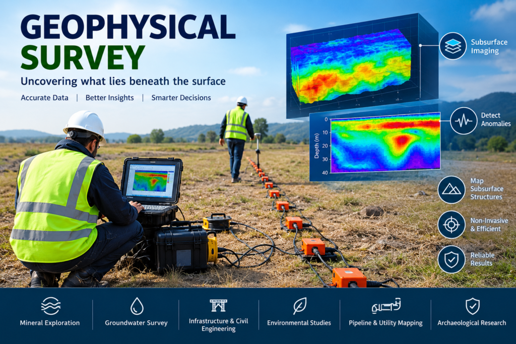
A geophysical survey is a scientific approach used to investigate conditions beneath the ground by measuring physical properties such as electrical resistivity, electromagnetic response, seismic velocity, magnetic susceptibility or variations in gravity.
Instead of relying entirely on excavation or drilling, geophysical techniques can provide information about subsurface structures over an area. Depending on the objective, a project may use one technique or combine several methods to develop a more reliable interpretation.
Modern geophysics is used in groundwater exploration, mineral investigation, construction planning, infrastructure development, environmental assessment, geological mapping and subsurface utility investigation. The U.S. Geological Survey identifies electrical, electromagnetic, potential-field and seismic techniques among the established approaches used for geophysical investigation.
What Is a Geophysical Survey?
A geophysical survey involves collecting measurements that reveal variations in the physical properties of the subsurface.
The basic principle is relatively straightforward: different geological materials have different physical characteristics. Rock, soil, groundwater, clay, weathered zones, metallic objects, cavities and other subsurface features can produce measurable differences.
For example, electrical resistivity methods measure how strongly subsurface materials resist electrical current. Electromagnetic techniques measure responses associated with electrical conductivity, while seismic methods examine how waves travel through the ground.
These measurements are processed and interpreted to develop models, profiles or maps of subsurface conditions.
Importantly, geophysical data are generally indirect measurements. They help identify patterns and anomalies, but interpretation should consider geological information, boreholes, surface observations and other available evidence.
How Does a Geophysical Survey Work?
Although procedures vary by technique, a typical investigation follows several stages.
1. Define the investigation objective
The first step is identifying what needs to be investigated.
The objective might include:
- locating groundwater-bearing formations
- mapping geological layers
- identifying faults and fractures
- determining depth to bedrock
- locating buried utilities
- investigating potential voids
- characterizing a construction site
- supporting mineral exploration
- assessing subsurface environmental conditions
2. Select the appropriate method
The method depends on the target, expected depth, ground conditions, accessibility and required resolution.
A single method may be sufficient for a relatively simple investigation, while complex projects can benefit from multiple complementary techniques.
3. Collect field measurements
Specialized instruments are positioned along survey lines, grids or other planned locations. Measurements are recorded together with their spatial positions.
Modern equipment and positioning systems can make it possible to efficiently collect large quantities of spatially referenced data.
4. Process and interpret the data
Raw measurements normally require quality control, processing and interpretation. The resulting datasets may be represented as profiles, sections, maps or three-dimensional models.
5. Integrate the results
The strongest interpretation often comes from combining geophysical information with geological, hydrological, topographical or engineering data.
USGS research has demonstrated the value of integrating complementary methods such as electromagnetic surveying, GPR, electrical resistivity tomography and seismic techniques for site characterization.
Major Geophysical Survey Methods
There is no single geophysical method suitable for every project. Each technique responds to different physical properties.
1. Electrical Resistivity Survey
Electrical resistivity surveying measures variations in the electrical resistance of subsurface materials.
Electrodes are placed in the ground and an electrical current is introduced. The resulting measurements can be used to estimate variations in subsurface resistivity.
Electrical resistivity techniques can be useful for:
- groundwater investigation
- geological layer mapping
- weathered-zone identification
- fracture investigation
- void investigation
- engineering site characterization
- environmental studies
Electrical resistivity is also used by government geoscience organizations for groundwater and aquifer investigations. For example, Maharashtra’s Groundwater Surveys and Development Agency describes electrical resistivity and very-low-frequency electromagnetic methods among its geophysical approaches.
2. Seismic Survey
Seismic methods use artificially generated or naturally occurring seismic energy to understand subsurface properties.
Seismic waves travel through different materials at different velocities. Measuring their travel time can help characterize geological layers and interfaces.
Common applications include:
- depth-to-bedrock investigations
- engineering site characterization
- geological mapping
- infrastructure planning
- earthquake-related studies
- mineral and energy exploration
Seismic refraction and reflection are established surface geophysical techniques, while specialized surface-wave methods can provide information about subsurface shear-wave velocities.
3. Electromagnetic Survey
Electromagnetic, or EM, surveys investigate variations in the electrical conductivity and related electromagnetic properties of subsurface materials.
EM methods can be useful when investigating:
- conductive geological formations
- groundwater conditions
- buried infrastructure
- contamination-related anomalies
- mineralization
- shallow geological structures
The USGS notes that electromagnetic measurements can produce resistivity maps that help scientists understand differences in subsurface geology.
4. Ground Penetrating Radar Survey
Ground Penetrating Radar (GPR) uses electromagnetic pulses to investigate shallow subsurface features.
It can be particularly useful for:
- locating buried utilities
- detecting buried objects
- identifying shallow voids
- mapping concrete structures
- investigating pavement
- identifying shallow geological interfaces
- archaeological investigations
GPR performance depends strongly on ground conditions, material properties and the frequency of the antenna used.
The National Centre for Earth Science Studies describes GPR as a near-surface technique capable of mapping shallow layers, buried objects and structural features.
5. Magnetic Survey
Magnetic surveys measure variations in the Earth’s magnetic field caused by differences in magnetic properties of subsurface materials.
They are widely used for geological and mineral investigations.
Magnetic data can help identify:
- geological contacts
- faults and structures
- magnetic rock units
- mineralization-related anomalies
- buried ferrous objects
- regional geological patterns
Large-scale magnetic surveys can also be conducted from airborne platforms. USGS Earth MRI information describes airborne magnetic mapping as a method for identifying rock types, faults and signatures associated with potential mineral deposits.
6. Gravity Survey
Gravity surveying measures small variations in the Earth’s gravitational field.
Differences in subsurface density can create measurable gravity anomalies. These anomalies can provide information about geological structures and density variations.
Gravity surveys may be applied to:
- regional geological mapping
- structural studies
- mineral exploration
- basin investigations
- subsurface density studies
Gravity and magnetic measurements are categorized by USGS among potential-field geophysical methods.
Applications of Geophysical Surveys
Geophysical surveys have applications across several industries because subsurface conditions can influence engineering, environmental and resource-development decisions.
Groundwater Exploration
One of the important applications is identifying geological conditions that may influence groundwater occurrence.
Electrical resistivity, electromagnetic and related techniques can help investigate subsurface formations, weathered zones, fractures and potential groundwater-bearing structures.
However, a geophysical anomaly should not automatically be interpreted as proof of a productive groundwater source. Geological interpretation and, where appropriate, drilling and well testing remain important for confirmation.
Construction and Infrastructure
Before major construction projects begin, understanding subsurface conditions can help support planning.
Geophysical investigations may contribute information about:
- soil and rock interfaces
- bedrock depth
- weathered zones
- fractures
- cavities
- buried infrastructure
- geological structures
For roads, bridges, buildings, industrial facilities and other infrastructure, combining geophysical information with conventional geotechnical investigation can improve understanding of site conditions.
Mining and Mineral Exploration
Mining projects often require information about geological structures and potential mineralized zones.
Magnetic, electromagnetic, gravity, resistivity and seismic methods can be selected according to the geological target.
USGS guidance notes that surface geophysics can help characterize deposits, identify geological contacts and support decisions about drilling locations.
Environmental Investigation
Geophysical methods can also support environmental investigations by identifying subsurface anomalies and areas requiring additional examination.
Depending on site conditions, electromagnetic, resistivity and GPR techniques can contribute to investigations involving buried structures, utilities, disturbed ground and other subsurface features.
Geological Mapping
Geophysical measurements can extend geological understanding beyond what is visible at the surface.
Magnetic, gravity, electrical and seismic datasets can reveal variations that help geoscientists interpret geological boundaries and structures.
Why Use a Geophysical Survey?
A properly designed survey can provide several advantages.
Non-invasive or minimally invasive investigation
Many surface geophysical methods can investigate the subsurface without extensive excavation.
Wider spatial coverage
Instead of investigating only individual points, geophysical surveys can provide continuous profiles or area-wide datasets.
Better targeting of drilling
Geophysical results can help identify areas that warrant further borehole or drilling investigation.
Faster reconnaissance
For suitable projects, geophysical techniques can collect information over relatively large areas before more intensive investigation.
Multidisciplinary integration
Geophysical data can be combined with geological mapping, borehole logs, geotechnical data, remote sensing and other information.
USGS research specifically highlights the usefulness of surface geophysical methods for characterizing subsurface conditions and supporting drilling strategies.
How to Choose the Right Geophysical Survey Method
The best technique depends on the question being asked, rather than simply the equipment available.
Consider these factors:
| Project requirement | Potentially relevant methods |
|---|---|
| Groundwater investigation | Resistivity, EM, seismic |
| Buried utility detection | GPR, EM |
| Geological structure | Magnetic, gravity, seismic, resistivity |
| Mineral exploration | Magnetic, EM, gravity, resistivity |
| Bedrock mapping | Seismic, resistivity, GPR |
| Shallow subsurface mapping | GPR, resistivity, EM |
| Engineering site characterization | Seismic, resistivity, GPR |
| Regional geological mapping | Magnetic, gravity, airborne EM |
This table is only a starting point. Actual method selection should consider geology, target depth, ground conditions, site accessibility, cultural noise and the resolution required.
NCESS describes an integrated approach using GPR, electrical resistivity, VLF and gamma-ray methods to obtain complementary information about near-surface conditions.
Geophysical Survey vs Conventional Investigation
Geophysical investigation and conventional drilling should not necessarily be treated as competing approaches.
They often work best together.
A borehole provides direct information at a particular location, while geophysical surveying can help characterize variations between investigation points.
For example, a project could use:
Geophysical survey → identify anomalies → select investigation locations → drill/borehole verification → integrate results
This approach can help create a more complete subsurface model.
Geophysical surveys therefore work particularly well as part of a broader investigation strategy rather than as an automatic replacement for all geological or geotechnical investigation.
Factors That Affect Geophysical Survey Results
A successful survey depends on more than the instrument.
Important considerations include:
- geological conditions
- soil moisture
- electrical conductivity
- surface access
- buried infrastructure
- electromagnetic interference
- cultural noise
- target size
- target depth
- survey spacing
- instrument frequency
- positioning accuracy
- data-processing approach
- quality of geological control
This is why the survey design should be based on the target and site conditions before fieldwork begins.
The Role of Integrated Geophysical Investigation
Complex projects often benefit from combining multiple techniques.
For example, resistivity may provide useful information about electrical properties while seismic data provide information related to wave velocities. GPR may add high-resolution information about shallow features, while magnetic data can contribute geological or structural information.
The methods do not necessarily produce identical results. Their value comes from their complementary responses to different physical properties.
An integrated interpretation can therefore provide greater confidence than relying on a single dataset.
What Should a Geophysical Survey Report Include?
A professional report may include:
- Project objectives
- Site description
- Survey methodology
- Equipment and acquisition parameters
- Survey locations
- Field observations
- Data-processing methodology
- Maps and profiles
- Interpreted anomalies
- Geological interpretation
- Limitations and uncertainties
- Conclusions
- Recommendations for further investigation
The exact contents should be adapted to the project requirements and the selected geophysical method.
FAQs About Geophysical Survey
What is a geophysical survey?
A geophysical survey is a method of investigating subsurface conditions by measuring physical properties such as electrical resistivity, electromagnetic response, seismic velocity, magnetic variation or gravity.
What are the main types of geophysical surveys?
Common methods include electrical resistivity, seismic, electromagnetic, GPR, magnetic and gravity surveys. Other specialized techniques may be selected depending on the project objective.
Is a geophysical survey the same as a geological survey?
No. A geological survey generally focuses on the observation and interpretation of rocks, soils and geological features, while geophysical surveying measures physical properties to infer subsurface conditions. The two approaches can complement one another.
Can geophysical surveys find groundwater?
Certain geophysical methods can help identify subsurface conditions and formations associated with groundwater occurrence. Resistivity and electromagnetic techniques are commonly used for this purpose, but geophysical results should be interpreted with geological and hydrogeological information.
Can geophysical surveys locate underground utilities?
Yes. Depending on the utility and site conditions, GPR and electromagnetic techniques can assist with locating buried utilities and other subsurface features.
Are geophysical surveys useful before construction?
They can be. Geophysical investigations may help identify geological interfaces, bedrock, voids, buried structures and other subsurface conditions that may be relevant to engineering planning.
Does every project need multiple geophysical methods?
No. Some projects may be adequately addressed with one technique. More complex investigations may benefit from multiple methods because different techniques measure different physical properties.
Can geophysical surveys replace drilling?
Not generally. Geophysical surveys provide indirect information, while drilling can provide direct subsurface samples and measurements. In many projects, the two approaches are most useful when integrated.
Conclusion
A geophysical survey provides a practical way to investigate the hidden subsurface by measuring physical properties that vary between geological materials and structures.
Electrical resistivity, seismic, electromagnetic, GPR, magnetic and gravity methods each have different strengths. The appropriate method depends on the investigation objective, expected target depth, geological environment and required resolution.
For groundwater exploration, construction, infrastructure, mineral exploration, environmental investigation and geological mapping, geophysical techniques can provide valuable information before or alongside more intensive investigations.
The key is not simply choosing the most advanced instrument. The quality of a geophysical investigation depends on matching the right method to the right subsurface question and interpreting the results within their geological context.
For projects requiring detailed subsurface understanding, a properly designed geophysical investigation can become an important part of a broader site-characterization and decision-making strategy.