Why Underground Utility Detection is Critical Before Excavation
Underground utility strikes are among the most common and costly challenges faced during road construction, highway development, Smart City projects, metro rail corridors, industrial infrastructure, and urban redevelopment works. Accidentally damaging a buried water pipeline, electrical cable, fiber optic network, sewer line, or gas pipeline can result in project delays, safety hazards, service interruptions, legal liabilities, and significant repair costs.
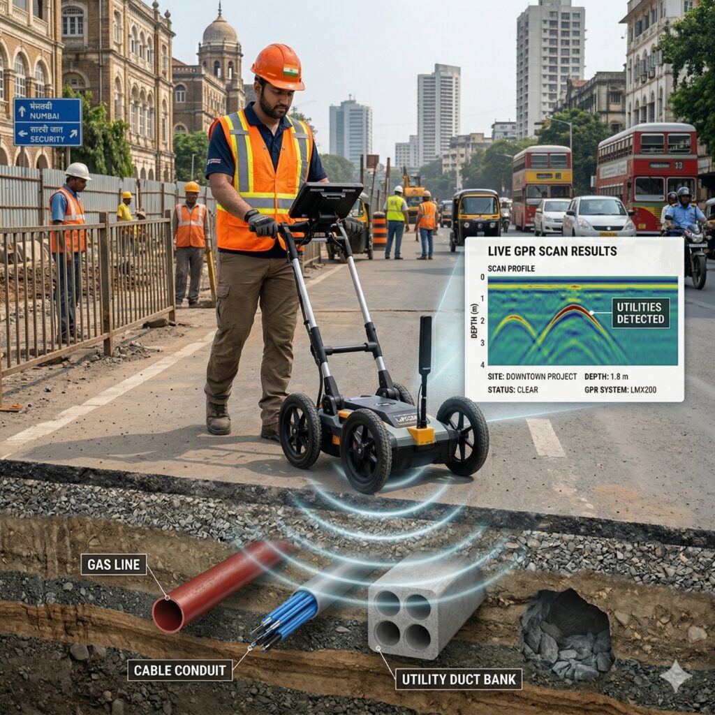
To minimize these risks, Garud Survey Private Limited provides advanced GPR Survey and Underground Utility Mapping Services across India using industry-leading Ground Penetrating Radar technology. Our utility mapping projects are executed using MALA GX HDR and MALA Easy Locator Pro WideRange, among the most advanced GPR systems available for underground utility detection and subsurface investigation. These systems enable high-resolution utility detection, accurate depth estimation, and reliable underground mapping for engineering and construction projects.
Depending on site conditions and antenna configuration, GPR surveys can detect underground utilities ranging from shallow communication cables to deeper pipelines and utility corridors. Combined with professional interpretation, CAD drafting, and GIS-based mapping, this technology provides project teams with accurate subsurface information before excavation begins.
By identifying hidden utilities in advance, contractors, EPC companies, consultants, industries, and government agencies can improve construction planning, reduce utility conflicts, enhance safety, and avoid costly project disruptions. This makes a GPR Survey for Underground Utility Mapping an essential pre-construction activity for modern infrastructure development projects.
⸻
What is a GPR Survey?
Ground Penetrating Radar (GPR) is a non-destructive geophysical survey technique used to detect, locate, and map underground utilities and subsurface structures without excavation.
The GPR system transmits high-frequency electromagnetic waves into the ground. When these signals encounter buried objects such as pipelines, cables, ducts, foundations, tanks, or underground structures, a portion of the signal reflects back to the receiver. Advanced software processes this information to create accurate underground utility maps and subsurface profiles.
Unlike traditional trial pits or exploratory excavation, GPR surveys provide valuable underground information without disturbing the ground surface, making them one of the safest and most efficient utility detection methods available today.
⸻
How GPR Survey Works and What Equipment is Used
A professional underground utility mapping survey follows a structured workflow:
Site Assessment
Survey specialists review available utility records, project drawings, and site conditions to identify potential utility corridors and risk areas.
Data Acquisition
GPR equipment is moved systematically across the survey area while continuously collecting subsurface data.
Data Processing
The collected radar data is processed using specialized software to identify utility signatures and underground anomalies.
Utility Interpretation
Experienced geophysicists analyze radargrams to determine utility location, alignment, and depth.
CAD and GIS Mapping
Detected utilities are converted into CAD drawings, GIS layers, utility maps, and project-ready engineering deliverables.
GPR Equipment Used by Garud Survey
Garud Survey Private Limited utilizes:
* MALA GX HDR
* MALA Easy Locator Pro WideRange
These advanced GPR systems are designed for high-resolution underground utility detection, cable tracing, pipeline mapping, and subsurface investigations across a wide range of infrastructure projects.
⸻
GPR Depth Range and Detection Capability
One of the most frequently asked questions is how deep a GPR survey can detect underground utilities.
The actual depth depends on soil conditions, moisture content, utility type, and antenna frequency.
Antenna Frequency Typical Detection Depth Best Application
| Antenna Frequency | Typical Detection Depth | Recommended Applications |
|---|---|---|
| 800–1000 MHz | Up to 1–1.5 m | Shallow cables and concrete scanning |
| 600 MHz | Up to 2–3 m | Urban utility mapping |
| 400 MHz | Up to 4–5 m | Road and infrastructure projects |
| 200–250 MHz | Up to 6–8 m | Deep utility investigations |
| 100 MHz | Up to 10–15 m* | Geological and deep subsurface studies |
*Depth penetration varies depending on ground conditions.
Typical Utility Depths Detected
| Utility Type | Typical Depth Range |
|---|---|
| Fiber Optic Cables | 0.5–1.5 m |
| Electrical Cables | 0.5–2 m |
| Water Pipelines | 1–3 m |
| Gas Pipelines | 1–3 m |
| Sewer Lines | 1–5 m |
| Storm Water Drains | 2–6 m |
For most road, highway, Smart City, and municipal projects, underground utilities generally fall within the ideal detection range of GPR technology.
⸻
Underground Utilities That Can Be Detected
A professional GPR Utility Mapping Survey can help locate:
* Water supply pipelines
* Sewer networks
* Stormwater drainage systems
* Electrical power cables
* Fiber optic communication cables
* Gas pipelines
* Utility corridors
* Underground storage tanks
* Duct banks
* Concrete foundations
* Buried structures
* Abandoned utility lines
This information allows engineers and contractors to avoid accidental utility damage during excavation.
⸻
How Much Area Can Be Covered in a Day?
Survey productivity depends on utility density, traffic conditions, accessibility, project requirements, and required level of detail.
Typical Daily Coverage
| Project Type | Typical Daily Coverage |
|---|---|
| Open Land Utility Survey | 20,000–50,000 sq.m/day |
| Urban Utility Mapping | 10,000–30,000 sq.m/day |
| Industrial Facilities | 5,000–20,000 sq.m/day |
| Road Utility Mapping | 2–10 km/day |
| Highway Corridor Survey | 5–15 km/day |
In highly congested urban environments with multiple underground utilities, coverage may be lower due to detailed data acquisition and interpretation requirements.
⸻
Benefits of GPR Survey for Road, EPC and Infrastructure Projects
Prevents Utility Damage
Identifying underground utilities before excavation significantly reduces the risk of damaging critical infrastructure.
Reduces Project Delays
Utility strikes often result in work stoppages, redesign requirements, and increased project costs.
Improves Worker Safety
Knowledge of buried electrical cables and gas pipelines enhances site safety and reduces accident risks.
Supports Better Construction Planning
Accurate utility information helps engineers optimize excavation methods and construction sequencing.
Minimizes Unexpected Costs
Avoiding utility damage is far more economical than repairing damaged infrastructure and dealing with project delays.
Enables Utility Conflict Analysis
Utility mapping helps identify conflicts between proposed and existing infrastructure before construction begins.
⸻
Typical Deliverables of a Utility Mapping Survey
A professional underground utility mapping project typically includes:
* Underground Utility Layout Drawings
* Utility Corridor Maps
* CAD Drawings (DWG Format)
* GIS-Compatible Utility Data
* Utility Depth Information
* Utility Conflict Analysis
* Survey Interpretation Report
* Engineering Recommendations
These deliverables assist consultants, EPC contractors, municipal authorities, and project developers during planning and execution.
⸻
Industries Benefiting from Underground Utility Mapping
GPR Utility Mapping Services are widely used in:
* Road Construction Projects
* Highway Development Projects
* Smart City Initiatives
* Metro Rail Projects
* Railway Infrastructure
* Airport Expansion Projects
* Industrial Facilities
* Power Transmission Projects
* Oil & Gas Infrastructure
* Municipal Engineering Works
* Urban Redevelopment Projects
* Utility Corridor Development
As infrastructure investments continue to grow across India, underground utility mapping has become a critical component of modern project planning.
⸻
Why Choose Garud Survey Private Limited?
Garud Survey Private Limited is a trusted provider of advanced surveying and geophysical investigation services across India.
Our expertise includes:
* GPR Survey Services
* Underground Utility Mapping
* Underground Cable Detection
* Pipeline Mapping Surveys
* Utility Corridor Mapping
* GIS-Based Utility Mapping
* CAD Deliverables
* Nationwide Project Execution
* Fast Turnaround Time
* Technical Support by Experienced Professionals
We help contractors, EPC companies, consultants, industries, and government agencies reduce excavation risks and improve project outcomes.
⸻
Frequently Asked Questions (FAQs)
What is a GPR Survey used for?
A GPR Survey is used to detect and map underground utilities, buried structures, pipelines, cables, and subsurface features before excavation or construction activities.
Can GPR detect plastic pipes and non-metallic utilities?
Yes. Under suitable ground conditions, GPR can detect both metallic and non-metallic utilities, including plastic pipelines and fiber optic ducts.
Is GPR Survey non-destructive?
Yes. GPR is a completely non-invasive and non-destructive survey method that does not require excavation during investigation.
How accurate is underground utility mapping?
Accuracy depends on utility type, depth, soil conditions, and survey methodology. When performed by experienced professionals using advanced equipment, GPR surveys provide highly reliable results.
Why is utility mapping important before road construction?
Utility mapping helps prevent accidental utility strikes, improves safety, reduces delays, and supports efficient construction planning.
⸻
Conclusion
Before any road construction project, highway development, Smart City initiative, metro rail corridor, industrial expansion, or urban infrastructure project begins, understanding what lies beneath the ground is essential.
Hidden utilities such as water pipelines, sewer lines, electrical cables, fiber optic networks, and gas pipelines can create significant risks if not identified before excavation. A professional GPR Survey for Underground Utility Mapping provides accurate subsurface information that supports safer excavation, better engineering decisions, and more efficient project execution.
Using advanced technologies such as MALA GX HDR and MALA Easy Locator Pro WideRange, Garud Survey Private Limited delivers reliable GPR Survey, Utility Detection Survey, Underground Cable Detection, and Pipeline Mapping Services across India. Our team helps clients protect existing infrastructure, reduce project risks, and complete construction projects safely, efficiently, and cost-effectively.
Need Professional Underground Utility Mapping Services?
Contact Garud Survey Private Limited today for expert GPR Survey and Underground Utility Mapping solutions tailored to your road, infrastructure, industrial, railway, metro, airport, and Smart City projects anywhere in India.