Drone surveys generate valuable data—from high-resolution aerial imagery and orthomosaics to 3D models, point clouds, elevation data, and LiDAR datasets. But collecting the data is only the beginning.
The real challenge is how to view, manage, analyze, compare, measure, and share this data efficiently without depending entirely on complex desktop software.
This is where a cloud-based drone survey viewer and LiDAR visualization platform can make a significant difference.
What Is Drone Survey Data Management?
Drone Survey Data Management is the process of organizing, storing, accessing, visualizing, and analyzing the data generated from drone surveys.
A typical survey may contain:
- Orthomosaic maps
- DSM and DTM
- Point clouds
- LiDAR datasets
- 3D models
- Contours
- Elevation data
- LAS/LAZ files
- GeoTIFF and other survey formats
Instead of keeping these datasets on individual computers or transferring large files through drives and emails, a cloud platform provides a centralized environment where project teams can access the latest survey information.
Drone Survey Data Visualization: Turn Data into Information
Raw survey files can be difficult to interpret for project managers, engineers, clients, and other stakeholders.
Drone Survey Data Visualization makes this information easier to understand through interactive 2D and 3D views.
Users can visualize:
- Orthomosaics
- 3D terrain
- Point clouds
- LiDAR data
- 3D models
- Elevation surfaces
They can then perform measurements, inspect specific areas, and analyze the site without having to work directly with raw datasets.
For construction, mining, infrastructure, roads, real estate, and engineering projects, this can significantly improve how survey information is communicated and used.
LiDAR Point Cloud Viewer for Detailed 3D Data
LiDAR surveys generate millions of points representing terrain, buildings, roads, vegetation, and other objects.
A LiDAR Point Cloud Viewer allows users to interactively explore this information in 3D.
An Aerial LiDAR Data Viewer is particularly useful for large-area surveys such as:
- Topographic surveys
- Road and highway corridors
- Mining and quarry projects
- Construction sites
- Infrastructure projects
- Urban mapping
Instead of working only with raw LiDAR files, engineers and surveyors can visually inspect the surveyed environment and extract useful information from it.
Online LiDAR Viewer and LAS Viewer Online
Large LiDAR files are often stored in formats such as LAS and LAZ.
The traditional approach may require specialized desktop software to open and analyze these files. An Online LiDAR Viewer provides a more accessible alternative by allowing users to visualize survey data through a browser.
Similarly, a LAS Viewer Online can make it easier for teams to access and inspect LAS point-cloud data without transferring massive files between computers.
This is particularly useful when surveyors, engineers, consultants, contractors, and clients need access to the same project data.
Cloud Based Drone Survey Viewer: View Your Data Anywhere
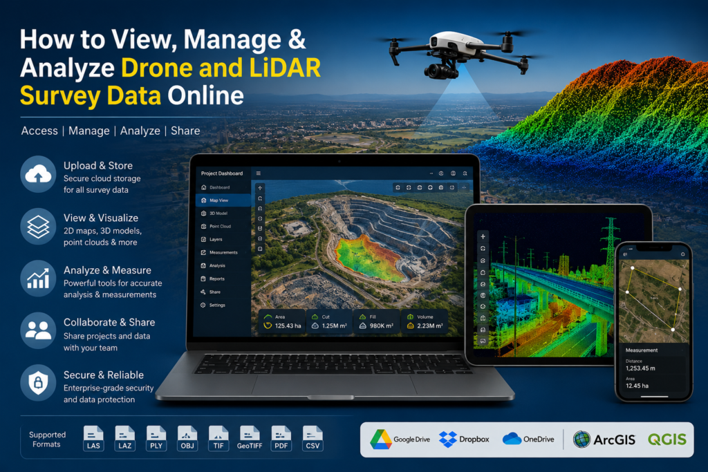
A Cloud Based Drone Survey Viewer brings survey data into a centralized online workspace.
The workflow becomes simple:
Upload → Visualize → Measure → Analyze → Compare → Collaborate
Instead of sending large survey files to every stakeholder, teams can access the project through a common platform.
This makes it easier to review site conditions, discuss findings, take measurements, and collaborate remotely.
Analyze More Than Just the 3D Model
A modern survey platform should do more than simply display a map or point cloud.
Measurements
Measure distances, areas, elevations, and other site dimensions directly from the survey.
Drone Volume Calculation
Calculate volumes for:
- Stockpiles
- Excavation
- Embankments
- Soil
- Aggregates
- Earthwork
This makes drone surveys particularly valuable for construction, mining, and quarry operations.
Cross-Sections & L-Sections
Create cross-sections and L-sections to understand terrain profiles and elevation changes. This is useful for roads, highways, drainage, canals, pipelines, mining, and infrastructure projects.
Survey Comparison
Compare surveys from different dates to identify changes over time.
For example:
January Survey → February Survey → March Survey
This can help construction and infrastructure teams monitor progress, excavation, earthwork, stockpile movement, and changes in site conditions.
Introducing DEX Platform
DEX Platform is a cloud-based environment designed to help users visualize, analyze, measure, compare, and collaborate on drone survey, photogrammetry, and LiDAR data.
With DEX, survey data can become more than a collection of large files. It can become an interactive project workspace that teams can access and use for real-world decision-making.
Whether you need a LiDAR Point Cloud Viewer, Online LiDAR Viewer, LAS Viewer Online, Aerial LiDAR Data Viewer, Cloud Based Drone Survey Viewer, Drone Survey Data Management solution, or Drone Survey Data Visualization platform, DEX brings these workflows together in one environment.
Why Use DEX?
One platform. Multiple survey workflows.
- View drone survey data in 2D and 3D
- Visualize photogrammetry and LiDAR datasets
- Explore point clouds
- Perform linear and area measurements
- Calculate volumes
- Create cross-sections and L-sections
- Compare surveys from different visits
- Collaborate with project teams
- Access survey information through the cloud
The objective is simple:
Make complex drone and LiDAR survey data easier to view, understand, analyze, and share.
Ready to Explore Your Survey Data?
If you have drone survey, photogrammetry, or LiDAR data and want to visualize, analyze, measure, compare, and collaborate online, explore the DEX Platform.
Get Started with DEX
 Visit DEX: https://dex.garudsurvey.com
 Call us: 7733911999
 WhatsApp us: 7733911999
 Email: info@garudsurvey.com
Have your drone or LiDAR survey data ready? Get in touch with our team and discover how DEX can simplify your survey data workflow.