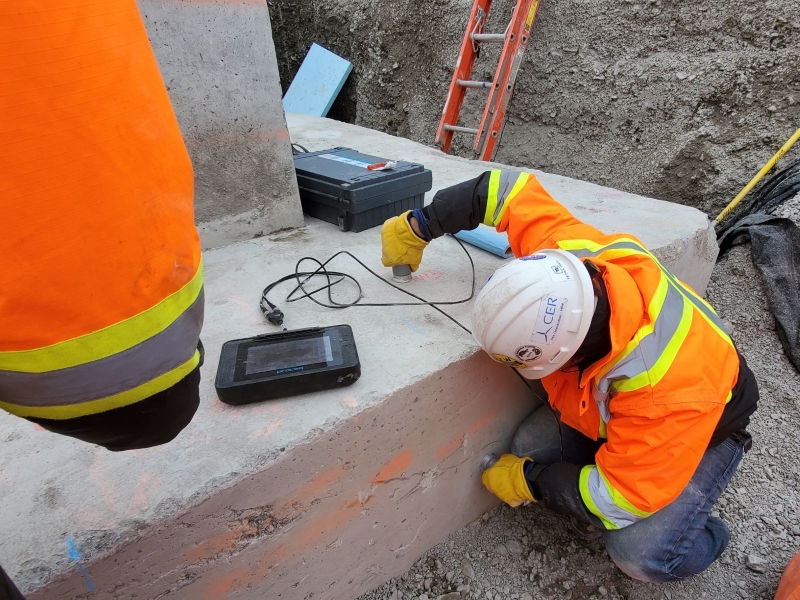
Construction Company

Drone Survey

Drone survey in lucknow

Transforming Urban Development with Advanced Drone Survey in Lucknow

Lucknow, the City of Nawabs, is rapidly transforming into a modern urban hub. With ongoing infrastructure projects, real estate expansion, and smart city initiatives, the demand for accurate and efficient land mapping solutions has never been higher. This is where drone survey in Lucknow is making a revolutionary impact. Combining innovation, precision, and speed, drone […]

Transforming Urban Development with Advanced Drone Survey in Lucknow Read More »

Drone Survey in Chennai

Revolutionizing Land Mapping with Drone Survey in Chennai – Garud Survey Private Limited

In the fast-growing urban landscape of Chennai, precision and efficiency in surveying are no longer a luxury but a necessity. Traditional land survey methods, though reliable, often fall short when it comes to speed, accessibility, and accuracy in complex environments. This is where Drone Survey in Chennai emerges as a game-changer. At the forefront of

Revolutionizing Land Mapping with Drone Survey in Chennai – Garud Survey Private Limited Read More »

Garud Survey: Leading the Way in Drone Surveying Services Across Bangalore

Leading the Way in Drone Surveying Services Across Bangalore

Introduction Bangalore, a hub of rapid urbanization and technological advancement, demands precise and efficient land surveying solutions. Traditional methods, while reliable, often fall short in speed, accuracy, and cost-effectiveness. Enter drone surveying—a game-changing technology that Garud Survey leverages to provide unmatched aerial mapping and geospatial data solutions across Bangalore. The Power of Drone Surveying in Modern Bangalore 1.

Leading the Way in Drone Surveying Services Across Bangalore Read More »

Drones in Disaster Management in India: A Lifesaving Innovation by Garud Survey

Drones in Disaster Management in India: A Lifesaving Innovation by Garud Survey

Introduction Disasters, whether natural or man-made, can strike without warning, leaving devastation in their wake. In India, where floods, earthquakes, cyclones, and landslides are frequent, efficient disaster management is crucial. Traditional methods often fall short due to logistical challenges and time constraints. However, drones have emerged as a game-changing technology in disaster response and recovery. Garud

Drones in Disaster Management in India: A Lifesaving Innovation by Garud Survey Read More »

Drone Survey Services in Haryana – Fast, Accurate & Affordable by Garud Survey

Drone Survey Services in Haryana – Fast, Accurate & Affordable by Garud Survey

The Future of Land Mapping: Drone Surveys in Haryana Land surveying has entered a new era with the advent of drone technology. In Haryana, where agriculture, infrastructure, and urban development are rapidly expanding, drone surveys have become an indispensable tool for precise and efficient data collection. Garud Survey, a trusted name in geospatial solutions, offers state-of-the-art Drone Survey in

Drone Survey Services in Haryana – Fast, Accurate & Affordable by Garud Survey Read More »

BB 5b469a0b 0009 44a7 99cf Fad32ea88756 Large 1024x576

Revolutionizing Land Mapping with Drone Survey in Jaipur: Garud Survey Leads the Way

ntroduction to Modern Surveying in the Pink City Jaipur’s rapid urbanization and infrastructure development demand precise, efficient land surveying solutions. Traditional methods using manual measurements and ground equipment are increasingly being replaced by cutting-edge drone survey in Jaipur – a faster, safer and more accurate alternative. Garud Survey, Jaipur’s premier drone surveying company, is transforming how architects, builders,

Revolutionizing Land Mapping with Drone Survey in Jaipur: Garud Survey Leads the Way Read More »

Leading the Skyward Revolution in Aerial Surveying Across India

Leading the Skyward Revolution in Aerial Surveying Across India

Introduction In today’s rapidly evolving world, accurate geospatial data is the backbone of industries like infrastructure, mining, agriculture, and urban planning. Traditional land-based surveying methods often fall short in efficiency, coverage, and precision—especially in India’s diverse and challenging terrains. This is where aerial survey companies in India are transforming the landscape with cutting-edge drone and aircraft-based solutions.

Leading the Skyward Revolution in Aerial Surveying Across India Read More »

Drones in Disaster Management in India: How Garud Survey is Saving Lives

Drones in Disaster Management in India: How Garud Survey is Saving Lives

Introduction Disasters—whether natural or man-made—can strike without warning, leaving devastation in their wake. In India, where floods, earthquakes, cyclones, and landslides are frequent, rapid response is crucial to saving lives and minimizing damage. Traditional disaster management methods often face challenges like inaccessible terrain, delayed assessments, and limited real-time data. Enter drones in disaster management—a revolutionary technology

Drones in Disaster Management in India: How Garud Survey is Saving Lives Read More »

Revolutionizing Pipeline Inspection with Drones: The Garud Survey Advantage

Revolutionizing Pipeline Inspection with Drones: The Garud Survey Advantage

Introduction The oil and gas industry relies heavily on pipeline networks to transport resources efficiently. However, maintaining these pipelines is a challenging task due to their vast lengths, remote locations, and harsh environmental conditions. Traditional inspection methods, such as manual inspections or ground-based surveys, are time-consuming, costly, and often risky. Enter drone pipeline inspection—a game-changing technology

Revolutionizing Pipeline Inspection with Drones: The Garud Survey Advantage Read More »

Lidar

The Growing Importance of LiDAR Survey in India for Accurate Land Mapping

Introduction In recent years, LiDAR (Light Detection and Ranging) Survey in India has gained significant traction due to its precision and efficiency in land mapping, urban planning, and infrastructure development. As a cutting-edge remote sensing technology, LiDAR provides high-resolution 3D data, making it indispensable for various industries. Garud Survey, a leading surveying company in India, leverages advanced LiDAR

The Growing Importance of LiDAR Survey in India for Accurate Land Mapping Read More »